IMAGES TAKEN NEAR TO
Academy Street, COATBRIDGE, ML5 3AZ
Introduction
This page details the photographs taken nearby to Academy Street, ML5 3AZ by members of the Geograph project.
The Geograph project started in 2005 with the aim of publishing, organising and preserving representative images for every square kilometre of Great Britain, Ireland and the Isle of Man.

There are currently over 7.5m images from over14,400 individuals and you can help contribute to the project by visiting https://www.geograph.org.uk
Image Map (Loading...)


Getting Data...Please wait
Leaflet Map data © OpenStreetMap
Images are licensed for reuse under creativecommons.org/licenses/by-sa/2.0
Notes
- Clicking on the map will re-center to the selected point.
- The higher the marker number, the further away the image location is from the centre of the postcode.
Image Listing (178 Images Found)
Images are licensed for reuse under creativecommons.org/licenses/by-sa/2.0
Image
Details
Distance
1

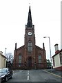
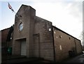
Church Street
Viewed from Gartsherrie Road at Sunnyside Road. St Andrew's Church is prominent. See also Image
Image: © Thomas Nugent
Taken: 20 Oct 2008
0.05 miles
2
St Andrew's Church of Scotland
Viewed from Baird Street.
Image: © Thomas Nugent
Taken: 22 Apr 2007
0.07 miles
3
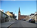
St Andrew's Church of Scotland
Viewed from the south
Image: © Elliott Simpson
Taken: 30 Oct 2008
0.08 miles
4
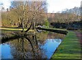
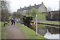
The canal basin
This canal basin at the side of the old Monkland Canal was possibly used to turn the barges around.
Image: © Malcolm Neal
Taken: 6 Apr 2019
0.08 miles
5
Summerlee Museum of Scottish Industrial Life - Monkland Canal
An in water remnant of the canal surveyed by James Watt and built to mainly carry coal.
Image: © Chris Allen
Taken: 24 Mar 2024
0.09 miles
6
Crichton Social Club
A building which prefers not to identify itself.
Image: © Jonathan Thacker
Taken: 20 Feb 2020
0.09 miles
7
A replica of Vulcan
A replica of the 1819 barge Vulcan (barge), the first all-iron hulled vessel, built for the Glasgow Garden Festival in 1988. The replica is probably the last hand riveted boat built on the Clyde and was Summerlee Museum and Monklands District Council's entry into the Festival.
In 2016, it was re-sited on the Monkland Canal, the Gartsherrie Cut runs through the site, following refurbishment with the aid of Scottish Waterways, Scottish Canals and the Heritage Lottery Fund. It rests on a cradle, slightly proud of the water and is fully accessible for visitors.
Image: © Malcolm Neal
Taken: 6 Apr 2019
0.09 miles
8

Summerlee Industrial museum
Howes Basin was used from transferring coal from the railway to the canal and now lies within the museum grounds.
Image: © Thomas Nugent
Taken: 20 Oct 2008
0.10 miles
9
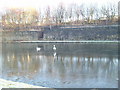
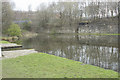
Swans Trying to get Ashore before The Pond Ices Over
At Summerlea Heritage Park, Coatbridge. The pond was a canal basin, part of the Monklands canal system and photo taken from old tow path
Image: © Sarah McGuire
Taken: 4 Jan 2006
0.10 miles
10
Howe's Basin
Canal basin on the Gartsherrie Cut, a branch of the Monklands Canal. This was once a large iron smelting area.
http://www.monklands.co.uk/summerlee/
Image: © Colin Smith
Taken: 29 Aug 2009
0.10 miles