IMAGES TAKEN NEAR TO
Academy Place, COATBRIDGE, ML5 3AX
Introduction
This page details the photographs taken nearby to Academy Place, ML5 3AX by members of the Geograph project.
The Geograph project started in 2005 with the aim of publishing, organising and preserving representative images for every square kilometre of Great Britain, Ireland and the Isle of Man.

There are currently over 7.5m images from over14,400 individuals and you can help contribute to the project by visiting https://www.geograph.org.uk
Image Map
Images are licensed for reuse under creativecommons.org/licenses/by-sa/2.0
Notes
- Clicking on the map will re-center to the selected point.
- The higher the marker number, the further away the image location is from the centre of the postcode.
Image Listing (160 Images Found)
Images are licensed for reuse under creativecommons.org/licenses/by-sa/2.0
Image
Details
Distance
1

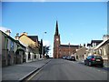
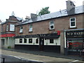
Church Street
Viewed from Gartsherrie Road at Sunnyside Road. St Andrew's Church is prominent. See also Image
Image: © Thomas Nugent
Taken: 20 Oct 2008
0.04 miles
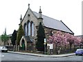
2
St Andrew's Church of Scotland
Viewed from the south
Image: © Elliott Simpson
Taken: 30 Oct 2008
0.05 miles
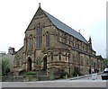
3
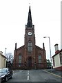
St Andrew's Church of Scotland
Viewed from Baird Street.
Image: © Thomas Nugent
Taken: 22 Apr 2007
0.06 miles
4
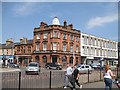
Airdrie Savings Bank, Coatbridge branch
The one that Lloyds did not get. The last surviving local savings bank, most of the others joined together as the Trustee Savings Bank, and eventually got swallowed up by Lloyds.
Image: © Richard Webb
Taken: 25 Jul 2008
0.09 miles
5
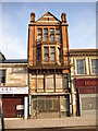
Derelict Building in Coatbridge Town Centre
This building can be found in Main Street Coatbridge in the town centre.
Image: © Stevie Spiers
Taken: 11 Apr 2010
0.10 miles
7
Former Church
Now Koko's play centre.
Image: © Thomas Nugent
Taken: 22 Apr 2007
0.11 miles
8
St Patrick's RC Church
An imposing building on Main Street.
Image: © Thomas Nugent
Taken: 22 Apr 2007
0.11 miles
9
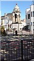
The Fountain
Well known Coatbridge landmark which used to sit a little to the west where the roundabout is now
Image: © Jim Smillie
Taken: 30 Sep 2015
0.11 miles
10
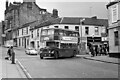
Turning into Water Street, Coatbridge ? 1970
Water Street has disappeared completely under a modern retail development along the south side of Main Street. The building behind the bus has shown some interesting development in the years since, as seen in this 2018 Streetview view https://goo.gl/maps/P8WgaoaPhnRgvwuX9 which shows that it has reverted from a painted finish to natural stonework, and more interestingly has had its chimney stacks rebuilt. The north side of Main Street comes within the Blairhill and Dunbeth Conservation Area and this is clearly the result of that.
Baxter's buses of Airdrie ran local services in the Airdrie and Coatbridge area, and were an independent family firm until 1962 when they were bought by major operator Eastern Scottish. After an initial period of integration, Eastern Scottish reverted to the Baxter's identity, which clearly had significant local goodwill. No.583 is an Eastern Scottish Bristol Lodekka, new in 1957 and later transferred to Baxter's operations complete with Baxter's livery. It is working the local service to the Townhead area.
This is one of a series of views featuring buses in the 60s, 70s, and 80s. http://www.geograph.org.uk/search.php?i=137652761
Image: © Alan Murray-Rust
Taken: 18 Sep 1970
0.11 miles