IMAGES TAKEN NEAR TO
Sussex Grove, COATBRIDGE, ML5 2TR
Introduction
This page details the photographs taken nearby to Sussex Grove, ML5 2TR by members of the Geograph project.
The Geograph project started in 2005 with the aim of publishing, organising and preserving representative images for every square kilometre of Great Britain, Ireland and the Isle of Man.

There are currently over 7.5m images from over14,400 individuals and you can help contribute to the project by visiting https://www.geograph.org.uk
Image Map
Images are licensed for reuse under creativecommons.org/licenses/by-sa/2.0
Notes
- Clicking on the map will re-center to the selected point.
- The higher the marker number, the further away the image location is from the centre of the postcode.
Image Listing (8 Images Found)
Images are licensed for reuse under creativecommons.org/licenses/by-sa/2.0
Image
Details
Distance
1
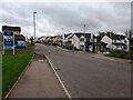
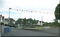
Housing development: Queens Gait
Looking up Jock Shaw Road, named after local football player (Airdrieonians & Rangers)
Image: © Jim Smillie
Taken: 28 Sep 2023
0.05 miles
2
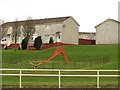
Slide, Glenboig
Playground between the B804 and houses.
Image: © Richard Webb
Taken: 20 Apr 2010
0.09 miles
3
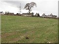
Croftfoot
A field with a track running around inside it.
Image: © Richard Webb
Taken: 20 Apr 2010
0.11 miles
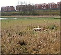
4
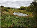
Pond near Glenboig
Just on the edge of village due to recent housing developments
Image: © Jim Smillie
Taken: 28 Sep 2023
0.14 miles
6
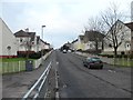
Gainside Road, Glenboig
The OS map refers to this area as Marnock - I think this is a mistake, it should be Marnoch judging by the road names...
Image: © Stephen Sweeney
Taken: 10 Jan 2012
0.21 miles
7
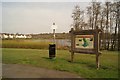
Glenboig Village Park
Garnqueen Loch and Marnock in the background.
Image: © Texas Radio and The Big Beat
Taken: 24 Apr 2010
0.22 miles
8
Garnqueen Swan
A swan in her nest on Garnqueen Loch.
Image: © Texas Radio and The Big Beat
Taken: 24 Apr 2010
0.24 miles