IMAGES TAKEN NEAR TO
Tay Street, COATBRIDGE, ML5 2NB
Introduction
This page details the photographs taken nearby to Tay Street, ML5 2NB by members of the Geograph project.
The Geograph project started in 2005 with the aim of publishing, organising and preserving representative images for every square kilometre of Great Britain, Ireland and the Isle of Man.

There are currently over 7.5m images from over14,400 individuals and you can help contribute to the project by visiting https://www.geograph.org.uk
Image Map
Images are licensed for reuse under creativecommons.org/licenses/by-sa/2.0
Notes
- Clicking on the map will re-center to the selected point.
- The higher the marker number, the further away the image location is from the centre of the postcode.
Image Listing (5 Images Found)
Images are licensed for reuse under creativecommons.org/licenses/by-sa/2.0
Image
Details
Distance
1
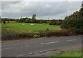
View over Lochview Road
Looking to the Lochview Family Golf Course
Image: © Jim Smillie
Taken: 28 Sep 2023
0.09 miles
2
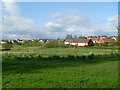
Coatbridge Golf Club
Municipal course to the northwest of the town, by Drumpellier Country Park.
Image: © Stephen Sweeney
Taken: 10 May 2010
0.11 miles
3
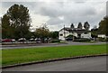
Lochview Family Golf Centre: Entrance
The course is on both sides of Townhead Road
Image: © Jim Smillie
Taken: 28 Sep 2023
0.16 miles
4

Lochview - Family Golf Centre - Clubhouse
Operated by North Lanarkshire Council.
Image: © G Laird
Taken: 12 Jul 2012
0.17 miles
5
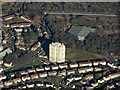
Townhead from the air
Image: © Thomas Nugent
Taken: 9 Feb 2018
0.21 miles