IMAGES TAKEN NEAR TO
Dunvegan Avenue, COATBRIDGE, ML5 2JG
Introduction
This page details the photographs taken nearby to Dunvegan Avenue, ML5 2JG by members of the Geograph project.
The Geograph project started in 2005 with the aim of publishing, organising and preserving representative images for every square kilometre of Great Britain, Ireland and the Isle of Man.

There are currently over 7.5m images from over14,400 individuals and you can help contribute to the project by visiting https://www.geograph.org.uk
Image Map (5 Images)
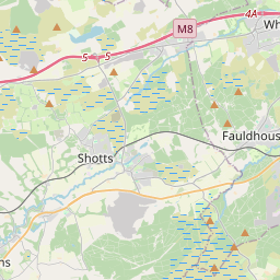

Leaflet Map data © OpenStreetMap
Images are licensed for reuse under creativecommons.org/licenses/by-sa/2.0
Notes
- Clicking on the map will re-center to the selected point.
- The higher the marker number, the further away the image location is from the centre of the postcode.
Image Listing (5 Images Found)
Images are licensed for reuse under creativecommons.org/licenses/by-sa/2.0
Image
Details
Distance
1
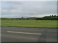
Playing fields in Drumpellier Country Park
From Townhead Road.
Image: © Stephen Sweeney
Taken: 10 May 2010
0.10 miles
2

Drumpelier Country Park
Playing fields with woodland beyond. The woods hide the odd difficult bog.
Image: © Richard Webb
Taken: 17 Aug 2010
0.18 miles
3
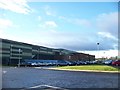
Townhead Community Centre and St Ambrose High School
Image: © Elliott Simpson
Taken: 5 Feb 2013
0.18 miles
4
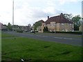
Lomond Road, Gartsherrie
Residential area in the north of Coatbridge.
Image: © Stephen Sweeney
Taken: 10 May 2010
0.20 miles
5
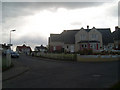
Morar Crescent, Townhead
In the northwest of Coatbridge.
Image: © Stephen Sweeney
Taken: 10 May 2010
0.23 miles