IMAGES TAKEN NEAR TO
Methven Terrace, COATBRIDGE, ML5 2BG
Introduction
This page details the photographs taken nearby to Methven Terrace, ML5 2BG by members of the Geograph project.
The Geograph project started in 2005 with the aim of publishing, organising and preserving representative images for every square kilometre of Great Britain, Ireland and the Isle of Man.

There are currently over 7.5m images from over14,400 individuals and you can help contribute to the project by visiting https://www.geograph.org.uk
Image Map (Loading...)


Getting Data...Please wait
Leaflet Map data © OpenStreetMap
Images are licensed for reuse under creativecommons.org/licenses/by-sa/2.0
Notes
- Clicking on the map will re-center to the selected point.
- The higher the marker number, the further away the image location is from the centre of the postcode.
Image Listing (9 Images Found)
Images are licensed for reuse under creativecommons.org/licenses/by-sa/2.0
Image
Details
Distance
1
Methven Terrace
As identified on 1950's map
Image: © Jim Smillie
Taken: 1 Apr 2022
0.00 miles
2
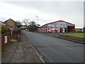
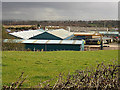
Northburn Metal Co, Coatbridge
In an industrial area to the north of the town.
Image: © Stephen Sweeney
Taken: 14 Feb 2012
0.02 miles
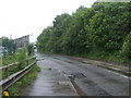
5

Waverley Street
Passing Northburn Industrial Estate on the edge of Coatbridge.
Image: © Richard Webb
Taken: 17 Aug 2010
0.08 miles
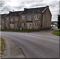
6
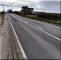
Coatbridge Road
About one half of house on right is in this square
Image: © Jim Smillie
Taken: 1 Apr 2022
0.11 miles
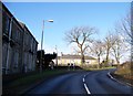
7

Waverley Street
Our space is once again littered with commercial rubbish. What if we dumped ours on the lawns of corporate executives?
Image: © Richard Webb
Taken: 17 Aug 2010
0.13 miles