IMAGES TAKEN NEAR TO
Lefroy Street, COATBRIDGE, ML5 1NB
Introduction
This page details the photographs taken nearby to Lefroy Street, ML5 1NB by members of the Geograph project.
The Geograph project started in 2005 with the aim of publishing, organising and preserving representative images for every square kilometre of Great Britain, Ireland and the Isle of Man.

There are currently over 7.5m images from over14,400 individuals and you can help contribute to the project by visiting https://www.geograph.org.uk
Image Map (Loading...)


Getting Data...Please wait
Leaflet Map data © OpenStreetMap
Images are licensed for reuse under creativecommons.org/licenses/by-sa/2.0
Notes
- Clicking on the map will re-center to the selected point.
- The higher the marker number, the further away the image location is from the centre of the postcode.
Image Listing (15 Images Found)
Images are licensed for reuse under creativecommons.org/licenses/by-sa/2.0
Image
Details
Distance
1

Lefroy Street
Leafy suburbs of Coatbridge.
Image: © Jim Smillie
Taken: 15 Jun 2010
0.06 miles
2

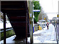
Through to the back court
'Close' allowing access to back court and outside stairs to upper level.
Image: © Jim Smillie
Taken: 15 Jun 2010
0.16 miles
4
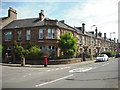
King Street at Finlaystone Street
Building on corner marked as 'Belgray Terrace 1902' joined onto already existing houses on King Street
Image: © Jim Smillie
Taken: 15 Jun 2010
0.19 miles
5

View towards Blairhill Street
One of the tower blocks at Merryston Court appears between the sandstone houses.
Image: © Jim Smillie
Taken: 15 Jun 2010
0.19 miles
6
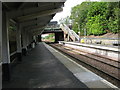
Blairhill railway station, looking WSW
View from platform 1 at Blairhill railway station, looking roughly WSW towards Glasgow, Milngavie, Helensburgh and Balloch.
Image: © Andrew Reid
Taken: 19 Aug 2011
0.21 miles
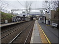
7
Coatbridge Central railway station, looking NNW
View from platform 1 Coatbridge Central station, looking roughly NNW towards Cumbernauld.
Image: © Andrew Reid
Taken: 24 Aug 2011
0.21 miles
8

Blairhill Railway Station
The station between Easterhouse and Coatbridge Sunnyside on the North Clyde Line.
Image: © G Laird
Taken: 12 Jul 2012
0.23 miles
9

Blairhill railway station, North Lanarkshire, 2011
Opened in 1888 as "Drumpellier & Blairhill" by the North British Railway on what is now the line from Glasgow Queen Street Low Level to Edinburgh via Bathgate. In 1899 it was renamed "Blairhill & Gartsherrie", and in 1966 the name was shortened to just "Blairhill".
View west towards Bargeddie first station (closed - not to be confused with the open Bargeddie station on the Carmyle line) and Glasgow. A few years after this image was taken, the footbridge and booking office were replaced by something more modern. See Image for a 2019 view.
Image: © Nigel Thompson
Taken: 26 Mar 2011
0.23 miles
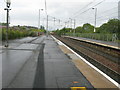
10
Blairhill railway station, North Lanarkshire
Opened in 1888 as "Drumpellier & Blairhill" by the North British Railway on what is now the line from Glasgow Queen Street Low Level to Edinburgh via Bathgate. In 1899 it was renamed "Blairhill & Gartsherrie", and in 1966 the name was shortened to just "Blairhill".
View west towards Bargeddie first station (closed - not to be confused with the open Bargeddie station on the Carmyle line) and Glasgow, shortly after the modern footbridge and booking office were installed. The old ones were still visible in the background when this image was taken.
Image: © Nigel Thompson
Taken: 12 Feb 2019
0.23 miles