IMAGES TAKEN NEAR TO
High Burnside Avenue, COATBRIDGE, ML5 1HZ
Introduction
This page details the photographs taken nearby to High Burnside Avenue, ML5 1HZ by members of the Geograph project.
The Geograph project started in 2005 with the aim of publishing, organising and preserving representative images for every square kilometre of Great Britain, Ireland and the Isle of Man.

There are currently over 7.5m images from over14,400 individuals and you can help contribute to the project by visiting https://www.geograph.org.uk
Image Map
Images are licensed for reuse under creativecommons.org/licenses/by-sa/2.0
Notes
- Clicking on the map will re-center to the selected point.
- The higher the marker number, the further away the image location is from the centre of the postcode.
Image Listing (21 Images Found)
Images are licensed for reuse under creativecommons.org/licenses/by-sa/2.0
Image
Details
Distance
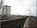
1
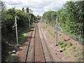
Langloan railway station (site), Lanarkshire, 2014
Opened in 1866 by the Caledonian Railway on what is today the line from Glasgow to Whifflet, this station closed to passengers in 1964.
View west towards Kirkwood and Glasgow. The main station building used to be to the right. When the line was reopened to passengers in 1993, Kirkwood (just visible in the distance) effectively replaced Langloan. Electrification of the line was taking place at the time this image was taken.
Image: © Nigel Thompson
Taken: 5 Jul 2014
0.05 miles
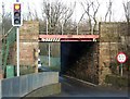
2
Railway bridge over Woodside Street, Coatbridge
Taken from the bridge over the Luggie Burn.
Image: © wrobison
Taken: 20 Aug 2022
0.13 miles
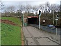
3
Coatbridge, Woodside Street
Railway bridge carrying the Rutherglen to Coatbrisge branch (now called the Whifflet Line) railway. Built in 1864 as part of the eastern contract.
Image: © Robert Murray
Taken: 27 Mar 2006
0.13 miles
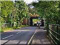
4
Railway bridge at Kirkwood train station
Carries the track over Woodside Street en route to Whifflet station.
Image: © Stephen Sweeney
Taken: 5 Mar 2008
0.14 miles
6
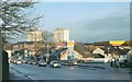
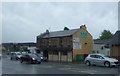
Bank Street, Coatbridge
The photograph was taken at the entrance of Drumpellier Crescent. On the left, the red sandstone building in the distance, behind a petrol station, is Langloan Primary School (thanks to another contributor – http://www.geograph.org.uk/profile/10850 – for the info): Image
The high flats in the background are (L-R) Blairgrove and Merryston; for a closer look, see Image and Image
Image: © Lairich Rig
Taken: 10 Dec 2004
0.18 miles
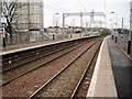
8
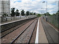
Kirkwood railway station, Lanarkshire
Opened in 1993 by British Rail on the line from Glasgow to Whifflet, this station effectively replaced an earlier station called Langloan a few hundred metres behind the camera position.
View west towards Bargeddie and Glasgow during electrification work. For a similar view some three years later on completion of the work, see Image
Image: © Nigel Thompson
Taken: 5 Jul 2014
0.19 miles
9
Kirkwood Railway Station
Taken from the end of the platform, the photograph reveals one of the many 'open' stations with only a platform on both sides and where you have to buy your ticket on the train.
Image: © G Laird
Taken: 29 Jan 2011
0.19 miles
10
Kirkwood railway station, Lanarkshire
Opened in 1993 by British Rail on the line from Glasgow to Whifflet, this station effectively replaced an earlier station called Langloan a few hundred metres behind the camera position.
View west towards Bargeddie and Glasgow following electrification. For a pre-electrification view from the same spot some three years earlier, see Image
Image: © Nigel Thompson
Taken: 9 Feb 2017
0.19 miles