IMAGES TAKEN NEAR TO
Langloan Street, COATBRIDGE, ML5 1HJ
Introduction
This page details the photographs taken nearby to Langloan Street, ML5 1HJ by members of the Geograph project.
The Geograph project started in 2005 with the aim of publishing, organising and preserving representative images for every square kilometre of Great Britain, Ireland and the Isle of Man.

There are currently over 7.5m images from over14,400 individuals and you can help contribute to the project by visiting https://www.geograph.org.uk
Image Map
Images are licensed for reuse under creativecommons.org/licenses/by-sa/2.0
Notes
- Clicking on the map will re-center to the selected point.
- The higher the marker number, the further away the image location is from the centre of the postcode.
Image Listing (25 Images Found)
Images are licensed for reuse under creativecommons.org/licenses/by-sa/2.0
Image
Details
Distance
2
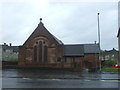
Church of Scotland, Coatbridge
On Bank Street.
Image: © JThomas
Taken: 29 Jun 2017
0.07 miles
3

Bank Street, Coatbridge
Looking north east on the A89.
Image: © JThomas
Taken: 29 Jun 2017
0.07 miles
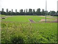
5

Coatbridge from the air
The track at Coatbridge Outdoor Sports Centre is prominent near the bottom of the photo. The Time Capsule leisure centre and Summerlee industrial museum can also be seen.
Image: © Thomas Nugent
Taken: 28 Jun 2011
0.09 miles
6
The West End public house, Bank Street, Coatbridge
Image: © JThomas
Taken: 29 Jun 2017
0.10 miles
7
Coatbridge Outdoor Sports Centre
Athletics track and sports centre, Langloan, Coatbridge.
Image: © Richard Webb
Taken: 25 Jul 2008
0.11 miles
8
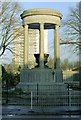
War memorial, Coatbridge
This memorial, which dates from 1924, is located at the junction of Blair Road and Image Behind it is West End Public Park (compare Image).
For more information on the memorial, which is the work of Edith Burnet Hughes, see its listed building report: http://portal.historicenvironment.scot/designation/LB50509 (at Historic Environment Scotland).
For another view, see Image
Image: © Lairich Rig
Taken: 10 Dec 2004
0.11 miles
9
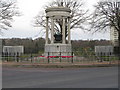
Coatbridge War Memorial
At the corner of Bank Street and Blair Road, some information about the memorial can be found in the British Listed Buildings website, http://www.britishlistedbuildings.co.uk/sc-50509-bank-street-coatbridge-war-memorial-
Image: © G Laird
Taken: 29 Jan 2011
0.11 miles
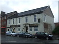
10
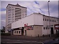
The Royal, Coatbridge
The Royal is a public house, the upper level is a night club venue. The tower block is called Merryston Court.
Image: © Stevie Spiers
Taken: 14 May 2009
0.13 miles