IMAGES TAKEN NEAR TO
Crighton Wynd, BELLSHILL, ML4 3NF

Introduction

This page details the photographs taken nearby to Crighton Wynd, ML4 3NF by members of the Geograph project.

The Geograph project started in 2005 with the aim of publishing, organising and preserving representative images for every square kilometre of Great Britain, Ireland and the Isle of Man.

There are currently over 7.5m images from over14,400 individuals and you can help contribute to the project by visiting https://www.geograph.org.uk

Image Map


Images are licensed for reuse under creativecommons.org/licenses/by-sa/2.0
Notes
  • Clicking on the map will re-center to the selected point.
  • The higher the marker number, the further away the image location is from the centre of the postcode.

Image Listing (10 Images Found)

Images are licensed for reuse under creativecommons.org/licenses/by-sa/2.0
Image
Details
Distance
1
New Edinburgh Road, Fallside
From the bottom of Sanderson Avenue, looking east.
Image: © Stephen Sweeney Taken: 15 Dec 2010
0.08 miles
2
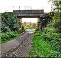
Through the bridge to the Nature Park
The bridge carries one of the Glasgow-Edinburgh lines
Image: © Jim Smillie Taken: 20 Oct 2021
0.13 miles
3
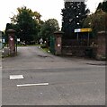
Bothwellpark Cemetery entrance
Old maps show the oldest part in the south-west of the present layout was known as Bothwell Cemetery.
Image: © Jim Smillie Taken: 20 Oct 2021
0.16 miles
4
Retail units on Philip Murray Road
Image: © JThomas Taken: 13 Sep 2021
0.17 miles
5
Bus stop and shelter on Old Edinburgh Road (B7001)
Image: © JThomas Taken: 13 Sep 2021
0.19 miles
6
Hotel Capo's, Fallside
Image: © Iain Thompson Taken: 14 Jan 2006
0.19 miles
7
Old Mine Nature Park
An old industrial area between two railway lines. Bothwell Park Colliery Pits No.1&2 were at the eastern end of the site and Bothwell Park Quarry was at the western end. For an information leaflet download Old Mine Nature Park Leaflet.pdf from https://forestryandland.gov.scot/visit/old-mine-nature-park
Image: © wrobison Taken: 9 Mar 2021
0.20 miles
8
Council Transport Department
Unusual building probably dating from 1950s/1960's
Image: © Jim Smillie Taken: 20 Oct 2021
0.23 miles
9
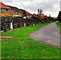
Cemetery boundary wall
North east corner of Bothwellpark Cemetery
Image: © Jim Smillie Taken: 20 Oct 2021
0.25 miles
10
Service station on Old Edinburgh Road (B7001)
Image: © JThomas Taken: 13 Sep 2021
0.25 miles