IMAGES TAKEN NEAR TO
Earn Avenue, BELLSHILL, ML4 3LW
Introduction
This page details the photographs taken nearby to Earn Avenue, ML4 3LW by members of the Geograph project.
The Geograph project started in 2005 with the aim of publishing, organising and preserving representative images for every square kilometre of Great Britain, Ireland and the Isle of Man.

There are currently over 7.5m images from over14,400 individuals and you can help contribute to the project by visiting https://www.geograph.org.uk
Image Map (Loading...)


Getting Data...Please wait
Leaflet Map data © OpenStreetMap
Images are licensed for reuse under creativecommons.org/licenses/by-sa/2.0
Notes
- Clicking on the map will re-center to the selected point.
- The higher the marker number, the further away the image location is from the centre of the postcode.
Image Listing (15 Images Found)
Images are licensed for reuse under creativecommons.org/licenses/by-sa/2.0
Image
Details
Distance
1
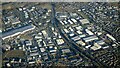
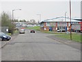
Righead Industrial Estate from the air
Righead is to the left of the A725 dual carriageway, with Bellshill Industrial Estate to the right of it.
Image: © Thomas Nugent
Taken: 19 Dec 2024
0.05 miles
3
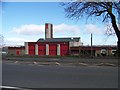
Strathclyde Fire and Rescue Station, Old Edinburgh Road
Image: © Elliott Simpson
Taken: 25 Mar 2009
0.09 miles
4
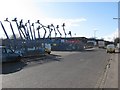
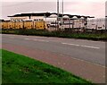
Katrine Avenue
Nationwide Platforms on Katrine Avenue, Righead Industrial Estate.
Image: © Richard Webb
Taken: 1 Apr 2010
0.10 miles
5
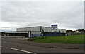
Righead Industrial Estate
Looking along James Street.
Image: © Richard Webb
Taken: 23 Apr 2010
0.15 miles
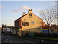
6
Council Transport Department
Unusual building probably dating from 1950s/1960's
Image: © Jim Smillie
Taken: 20 Oct 2021
0.15 miles
8
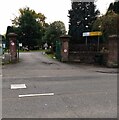
Bothwellpark Cemetery entrance
Old maps show the oldest part in the south-west of the present layout was known as Bothwell Cemetery.
Image: © Jim Smillie
Taken: 20 Oct 2021
0.18 miles
9
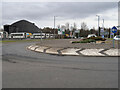
Roundabout on New Edinburgh Road, Belziehill
The roundabout gives access the petrol station on the right as well as a fast food outlet, a Motel and a small housing development. On the left is the North Lanarkshire Roads Department yard.
Image: © wrobison
Taken: 9 Mar 2021
0.20 miles
10
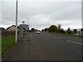
Bus stop and shelter on Old Edinburgh Road (B7001)
Image: © JThomas
Taken: 13 Sep 2021
0.20 miles