IMAGES TAKEN NEAR TO
Katrine Avenue, BELLSHILL, ML4 3LS
Introduction
This page details the photographs taken nearby to Katrine Avenue, ML4 3LS by members of the Geograph project.
The Geograph project started in 2005 with the aim of publishing, organising and preserving representative images for every square kilometre of Great Britain, Ireland and the Isle of Man.

There are currently over 7.5m images from over14,400 individuals and you can help contribute to the project by visiting https://www.geograph.org.uk
Image Map
Images are licensed for reuse under creativecommons.org/licenses/by-sa/2.0
Notes
- Clicking on the map will re-center to the selected point.
- The higher the marker number, the further away the image location is from the centre of the postcode.
Image Listing (8 Images Found)
Images are licensed for reuse under creativecommons.org/licenses/by-sa/2.0
Image
Details
Distance
1
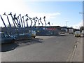
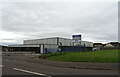
Katrine Avenue
Nationwide Platforms on Katrine Avenue, Righead Industrial Estate.
Image: © Richard Webb
Taken: 1 Apr 2010
0.02 miles
2
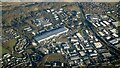
Righead Industrial Estate from the air
Righead is to the left of the A725 dual carriageway, with Bellshill Industrial Estate to the right of it.
Image: © Thomas Nugent
Taken: 19 Dec 2024
0.15 miles
4
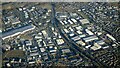
Righead Industrial Estate from the air
Righead is to the left of the A725 dual carriageway, with Bellshill Industrial Estate to the right of it.
Image: © Thomas Nugent
Taken: 19 Dec 2024
0.16 miles
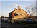
5
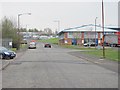
Righead Industrial Estate
Looking along James Street.
Image: © Richard Webb
Taken: 23 Apr 2010
0.17 miles
7
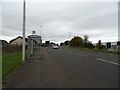
Bus stop and shelter on Old Edinburgh Road (B7001)
Image: © JThomas
Taken: 13 Sep 2021
0.19 miles
8
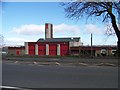
Strathclyde Fire and Rescue Station, Old Edinburgh Road
Image: © Elliott Simpson
Taken: 25 Mar 2009
0.20 miles