IMAGES TAKEN NEAR TO
Airlie Drive, BELLSHILL, ML4 3EH
Introduction
This page details the photographs taken nearby to Airlie Drive, ML4 3EH by members of the Geograph project.
The Geograph project started in 2005 with the aim of publishing, organising and preserving representative images for every square kilometre of Great Britain, Ireland and the Isle of Man.

There are currently over 7.5m images from over14,400 individuals and you can help contribute to the project by visiting https://www.geograph.org.uk
Image Map (Loading...)


Getting Data...Please wait
Leaflet Map data © OpenStreetMap
Images are licensed for reuse under creativecommons.org/licenses/by-sa/2.0
Notes
- Clicking on the map will re-center to the selected point.
- The higher the marker number, the further away the image location is from the centre of the postcode.
Image Listing (6 Images Found)
Images are licensed for reuse under creativecommons.org/licenses/by-sa/2.0
Image
Details
Distance
1
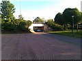
Underpass Bellshill
North Road Underpass looking south towards Bellshill cross.
Image: © Jim G
Taken: 20 May 2011
0.11 miles
3
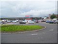
Bellshill Tesco
Tesco Extra Superstore on North Road.
Image: © Ross Watson
Taken: 14 Aug 2012
0.23 miles
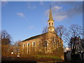
4
United Free Church of Scotland, Bellshill
Image: © Stevie Spiers
Taken: 10 May 2009
0.24 miles
5
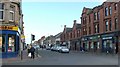
Main Street, Bellshill
The picture was taken from the pavement at the NW side of the junction of Main Street and North Road / Hamilton Road.
Image: © Lairich Rig
Taken: 11 Mar 2005
0.25 miles
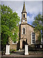
6
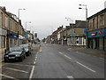
Main Street, Bellshill
At the junction with Motherwell Road.
Image: © G Laird
Taken: 18 Oct 2009
0.25 miles