IMAGES TAKEN NEAR TO
Robert Burns Quadrant, BELLSHILL, ML4 3DF
Introduction
This page details the photographs taken nearby to Robert Burns Quadrant, ML4 3DF by members of the Geograph project.
The Geograph project started in 2005 with the aim of publishing, organising and preserving representative images for every square kilometre of Great Britain, Ireland and the Isle of Man.

There are currently over 7.5m images from over14,400 individuals and you can help contribute to the project by visiting https://www.geograph.org.uk
Image Map
Images are licensed for reuse under creativecommons.org/licenses/by-sa/2.0
Notes
- Clicking on the map will re-center to the selected point.
- The higher the marker number, the further away the image location is from the centre of the postcode.
Image Listing (13 Images Found)
Images are licensed for reuse under creativecommons.org/licenses/by-sa/2.0
Image
Details
Distance
1
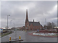
Bellshill West Church, Bellshill
Showing the roundabout at the industrial estate.
Image: © wfmillar
Taken: 5 Mar 2009
0.11 miles
5
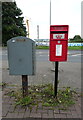
Postbox on Gartcosh Walk, Belshill
Postbox No. ML4 999.
Image: © JThomas
Taken: 13 Sep 2021
0.19 miles
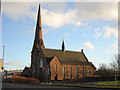
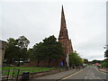
6
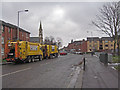
Main Street, Bellshill
St. Andrew's Church above the waste trucks.
Image: © wfmillar
Taken: 5 Mar 2009
0.20 miles
7
Cardinal Newman High School, Bellshill (Green)
Image: © Ian Paterson
Taken: 20 Feb 2008
0.20 miles
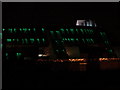
9
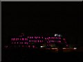
Cardinal Newman High School, Bellshill (Purple)
Illuminated by ever-changing lights at night, and reflecting the sun's rays by day, this building is a bit of a landmark any time of day.
http://www.cardinalnewman.n-lanark.sch.uk/
Image: © Ian Paterson
Taken: 20 Feb 2008
0.21 miles
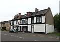
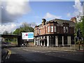
10
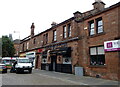
Saints & Sinners, Bellshill
On Main Street.
Image: © JThomas
Taken: 13 Sep 2021
0.21 miles