IMAGES TAKEN NEAR TO
Orbiston Drive, BELLSHILL, ML4 2LR
Introduction
This page details the photographs taken nearby to Orbiston Drive, ML4 2LR by members of the Geograph project.
The Geograph project started in 2005 with the aim of publishing, organising and preserving representative images for every square kilometre of Great Britain, Ireland and the Isle of Man.

There are currently over 7.5m images from over14,400 individuals and you can help contribute to the project by visiting https://www.geograph.org.uk
Image Map
Images are licensed for reuse under creativecommons.org/licenses/by-sa/2.0
Notes
- Clicking on the map will re-center to the selected point.
- The higher the marker number, the further away the image location is from the centre of the postcode.
Image Listing (6 Images Found)
Images are licensed for reuse under creativecommons.org/licenses/by-sa/2.0
Image
Details
Distance
2
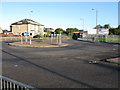
Roundabout on the B7029
The roads leaving this small roundabout lead to Bellshill (in the background), New Stevenston (to the right) and Motherwell (to the left).
Image: © G Laird
Taken: 5 Oct 2008
0.18 miles
4

Double rainbow over Riverbank Drive, Mossend
Image: © Alan O'Dowd
Taken: Unknown
0.21 miles
5
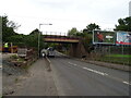
Railway bridge over Calder Road (B7029)
Carries the railway line from Glasgow Central to Edinburgh Waverley via Shotts.
Image: © JThomas
Taken: 13 Sep 2021
0.23 miles
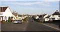
6
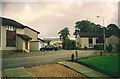
Riverbank Drive, Mossend
The Clydesdale Steel Works (in the background) was demolished a few years after this photo was taken.
Image: © Alan O'Dowd
Taken: Unknown
0.25 miles