IMAGES TAKEN NEAR TO
Leander Crescent, BELLSHILL, ML4 1JB
Introduction
This page details the photographs taken nearby to Leander Crescent, ML4 1JB by members of the Geograph project.
The Geograph project started in 2005 with the aim of publishing, organising and preserving representative images for every square kilometre of Great Britain, Ireland and the Isle of Man.

There are currently over 7.5m images from over14,400 individuals and you can help contribute to the project by visiting https://www.geograph.org.uk
Image Map (Loading...)


Getting Data...Please wait
Leaflet Map data © OpenStreetMap
Images are licensed for reuse under creativecommons.org/licenses/by-sa/2.0
Notes
- Clicking on the map will re-center to the selected point.
- The higher the marker number, the further away the image location is from the centre of the postcode.
Image Listing (10 Images Found)
Images are licensed for reuse under creativecommons.org/licenses/by-sa/2.0
Image
Details
Distance
1
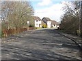
Leander Crescent
Leading to, and the main loop of the Calderglen Estate.
Image: © Richard Webb
Taken: 1 Apr 2010
0.06 miles
2
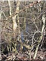
Thankerton Burn
Looking down on the burn which runs through a steep sided wooded defile, from the road running into the Calderglen Estate.
Image: © Richard Webb
Taken: 1 Apr 2010
0.08 miles
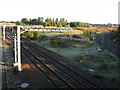
3
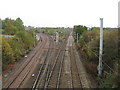
Railway Junction at Mossend
The line straight ahead leads to Motherwell while the line branching off to the left eventually leads to Edinburgh.
Image: © G Laird
Taken: 18 Oct 2009
0.13 miles
4
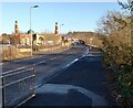
Clydesdale Road entering New Stevenson
Mosque in this and neighbouring square
Image: © Jim Smillie
Taken: 28 Nov 2022
0.19 miles
5
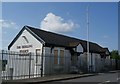
The Shieling (unoccupied)
Image: © Texas Radio and The Big Beat
Taken: 26 Aug 2010
0.19 miles
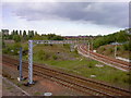
6
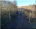
Railway Junction near Bellshill
The line in the foreground is the one which leads to the north from Motherwell. The bridge over this line which can just be seen in the background carries the line from Glasgow to Edinburgh which passes through Bellshill. The line on the right hand side of the picture is the link line between these 2 railway lines.
Image: © G Laird
Taken: 5 Oct 2008
0.20 miles
7
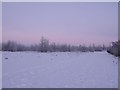
Former Ravenscraig Steel Works
Looking North on a cold, winter's day in 2010.
Image: © Rickoza
Taken: 4 Jan 2010
0.21 miles
8
Mossend Railway Junction
The line heading off to the left leads to Eurocentral and the line curving off to the right leads to Shotts and eventually Edinburgh. This photo was taken from the road bridge outside the former Clydesdale Steel Works.
Image: © Bertie Broomfield
Taken: 12 May 2010
0.22 miles
9
Railway Spur
Curving from line heading north to westbound line
Image: © Jim Smillie
Taken: 28 Nov 2022
0.23 miles
10
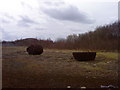
New Stevenston (Site of Iron Foundry)
Although this looks like a couple of giant rocks, its actually one lump of solid metal (left) and a giant ladle for pouring moulten metal (right). This is located on the site of an old iron foundry near the Thankerton Burn
Image: © Bertie Broomfield
Taken: 9 Apr 2010
0.23 miles