IMAGES TAKEN NEAR TO
Adamson Street, BELLSHILL, ML4 1DT
Introduction
This page details the photographs taken nearby to Adamson Street, ML4 1DT by members of the Geograph project.
The Geograph project started in 2005 with the aim of publishing, organising and preserving representative images for every square kilometre of Great Britain, Ireland and the Isle of Man.

There are currently over 7.5m images from over14,400 individuals and you can help contribute to the project by visiting https://www.geograph.org.uk
Image Map (Loading...)


Getting Data...Please wait
Leaflet Map data © OpenStreetMap
Images are licensed for reuse under creativecommons.org/licenses/by-sa/2.0
Notes
- Clicking on the map will re-center to the selected point.
- The higher the marker number, the further away the image location is from the centre of the postcode.
Image Listing (12 Images Found)
Images are licensed for reuse under creativecommons.org/licenses/by-sa/2.0
Image
Details
Distance
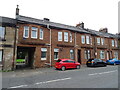
1

Holy Family Church & Parish Centre
Image: © Bertie Broomfield
Taken: 30 Dec 2002
0.11 miles
2
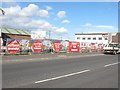
Building site, Main Street
Former industrial land awaiting redevelopment.
Image: © Richard Webb
Taken: 1 Apr 2010
0.14 miles

4
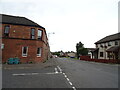
Clydesdale Road (B7029)
Looking west at the junction with Kirklee Road.
Image: © JThomas
Taken: 13 Sep 2021
0.16 miles
5
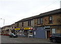
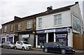
Convenience store and Post Office on Clydesdale Road (B7029)
Image: © JThomas
Taken: 13 Sep 2021
0.17 miles
8
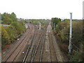
Railway Junction at Mossend
The line straight ahead leads to Motherwell while the line branching off to the left eventually leads to Edinburgh.
Image: © G Laird
Taken: 18 Oct 2009
0.21 miles
9
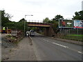
Railway bridge over Calder Road (B7029)
Carries the railway line from Glasgow Central to Edinburgh Waverley via Shotts.
Image: © JThomas
Taken: 13 Sep 2021
0.22 miles
10
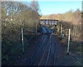
Railway Spur
Curving from line heading north to westbound line
Image: © Jim Smillie
Taken: 28 Nov 2022
0.24 miles