IMAGES TAKEN NEAR TO
Morar Court, HAMILTON, ML3 8UT
Introduction
This page details the photographs taken nearby to Morar Court, ML3 8UT by members of the Geograph project.
The Geograph project started in 2005 with the aim of publishing, organising and preserving representative images for every square kilometre of Great Britain, Ireland and the Isle of Man.

There are currently over 7.5m images from over14,400 individuals and you can help contribute to the project by visiting https://www.geograph.org.uk
Image Map
Images are licensed for reuse under creativecommons.org/licenses/by-sa/2.0
Notes
- Clicking on the map will re-center to the selected point.
- The higher the marker number, the further away the image location is from the centre of the postcode.
Image Listing (10 Images Found)
Images are licensed for reuse under creativecommons.org/licenses/by-sa/2.0
Image
Details
Distance
1
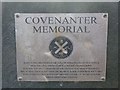
Plaque on memorial/grave at to Lady Watson Gardens, Hamilton, Lanarkshire
For photo of memorial, see http://www.geograph.org.uk/photo/2275703
Image: © Becky Williamson
Taken: 12 Feb 2011
0.10 miles
2
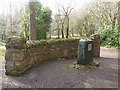
Covenanters' grave, Lady Watson Gardens, Hamilton, Lanarkshire
Two brothers named Smith, and another unknown Covenanter were killed and buried here after fighting in the Battle of Bothwell Bridge in 1679. The memorial was erected in 2008. For photo of plaque, see http://www.geograph.org.uk/photo/2275706
Image: © Becky Williamson
Taken: 12 Feb 2011
0.11 miles
3
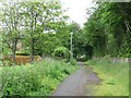
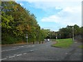
Highstonehall Road
A road, now blocked to larger vehicles as it has been replaced by newer roads to the west.
Image: © Richard Webb
Taken: 20 Jun 2011
0.17 miles
5

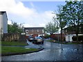
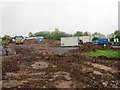
Neilsland Park
Informal woodland park with the appearance of being once the policies of a big house. The ground is wet which does not help as the place is being abused by illegal motorcyclists.
Image: © Richard Webb
Taken: 20 Jun 2011
0.19 miles
8
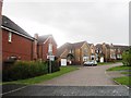
St Marks RC Primary School, demolished
Image: © Alex McGregor
Taken: 23 May 2013
0.21 miles
9

Neilsland Park
Woodland park, the presence of a ruined wall and lots of rhododendrons suggests that this was once the policies of a large house.
Image: © Richard Webb
Taken: 20 Jun 2011
0.22 miles
10

Covenanter memorial built into the wall of the Little Earnock estate policies
This memorial marked the site of three Covenanters' graves at Little Earnock. From memory, it was painted grey in 1988 when a Covenanter Trail was publicised to mark the 350th anniversary of the signing of the covenant in the kirkyard of Greyfriars Kirk in Edinburgh in 1638. By the time I took this photo, it had already been vandalised and shortly after was taken into protection by the local council. It was relocated in the Hamilton Old Parish Churchyard in 1995 - see http://www.covenanter.org.uk/Earnock/ I assume that Image was built to replace this memorial.
Image: © Elliott Simpson
Taken: Unknown
0.24 miles