IMAGES TAKEN NEAR TO
Muttonhole Road, HAMILTON, ML3 8RX
Introduction
This page details the photographs taken nearby to Muttonhole Road, ML3 8RX by members of the Geograph project.
The Geograph project started in 2005 with the aim of publishing, organising and preserving representative images for every square kilometre of Great Britain, Ireland and the Isle of Man.

There are currently over 7.5m images from over14,400 individuals and you can help contribute to the project by visiting https://www.geograph.org.uk
Image Map
Images are licensed for reuse under creativecommons.org/licenses/by-sa/2.0
Notes
- Clicking on the map will re-center to the selected point.
- The higher the marker number, the further away the image location is from the centre of the postcode.
Image Listing (5 Images Found)
Images are licensed for reuse under creativecommons.org/licenses/by-sa/2.0
Image
Details
Distance
1
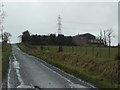
Haspielaw
Farm just off of Muttonhole Road, near Hamilton.
Image: © Stephen Sweeney
Taken: 5 Mar 2014
0.01 miles
2
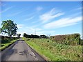
Road to Burnhead Farm Passing Haspielaw
Image: © Elliott Simpson
Taken: 14 Sep 2013
0.02 miles
3
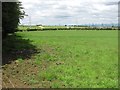
Pasture, Haspielaw
Wet grassland during a prolonged spell of rain.
Image: © Richard Webb
Taken: 20 Jun 2011
0.05 miles
4
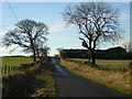
Road to Burnhead Farm Passing Haspielaw
Image: © Iain Thompson
Taken: 1 Jan 2006
0.06 miles
5
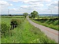
Road to Haspielaw
Big views from high ground south of Hamilton. The surrounding land is predominantly pasture. An opposite view: Image
Image: © Richard Webb
Taken: 20 Jun 2011
0.12 miles