IMAGES TAKEN NEAR TO
Strathaven Road, HAMILTON, ML3 7UY
Introduction
This page details the photographs taken nearby to Strathaven Road, ML3 7UY by members of the Geograph project.
The Geograph project started in 2005 with the aim of publishing, organising and preserving representative images for every square kilometre of Great Britain, Ireland and the Isle of Man.

There are currently over 7.5m images from over14,400 individuals and you can help contribute to the project by visiting https://www.geograph.org.uk
Image Map
Images are licensed for reuse under creativecommons.org/licenses/by-sa/2.0
Notes
- Clicking on the map will re-center to the selected point.
- The higher the marker number, the further away the image location is from the centre of the postcode.
Image Listing (5 Images Found)
Images are licensed for reuse under creativecommons.org/licenses/by-sa/2.0
Image
Details
Distance
1
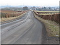
Limekilnburn Road
Looking towards the village of Quarter.
Image: © G Laird
Taken: 7 Mar 2010
0.21 miles
3
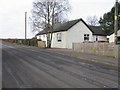
Station House (outside Quarter)
It is many years since the railway existed for which this was the Station House.
Image: © G Laird
Taken: 7 Mar 2010
0.23 miles
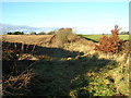
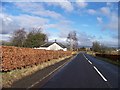
4
Station House, by Quarter
No railway here now, but this cottage lies on the route of the old Strathaven to Hamilton railway.
Image: © Gordon Brown
Taken: 5 May 2020
0.25 miles
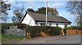
5
Approaching Station House, Quarter, from the west
Image: © Elliott Simpson
Taken: 14 Mar 2011
0.25 miles