IMAGES TAKEN NEAR TO
Hawksland Walk, HAMILTON, ML3 7NX
Introduction
This page details the photographs taken nearby to Hawksland Walk, ML3 7NX by members of the Geograph project.
The Geograph project started in 2005 with the aim of publishing, organising and preserving representative images for every square kilometre of Great Britain, Ireland and the Isle of Man.

There are currently over 7.5m images from over14,400 individuals and you can help contribute to the project by visiting https://www.geograph.org.uk
Image Map
Images are licensed for reuse under creativecommons.org/licenses/by-sa/2.0
Notes
- Clicking on the map will re-center to the selected point.
- The higher the marker number, the further away the image location is from the centre of the postcode.
Image Listing (6 Images Found)
Images are licensed for reuse under creativecommons.org/licenses/by-sa/2.0
Image
Details
Distance
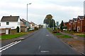
2
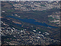
Hamilton and Strathclyde Park from the air
Silvertonhill in Hamilton is in the foreground, Bellshill and Motherwell are beyond the loch.
Image: © Thomas Nugent
Taken: 3 Dec 2018
0.17 miles
3
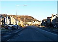
Silvertonhill Avenue, Hamilton
The old coal waste bing caught is in the winter sunshine, but it still looks ugly!
Image: © Elliott Simpson
Taken: 11 Jan 2011
0.21 miles
4
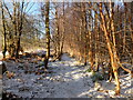
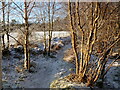
Woodland path under snow, Meikle Burn
An offshoot of the main Chatelherault Country Park path network, pictured on a sub-zero day during a spell of cold weather.
Image: © Alan O'Dowd
Taken: 8 Jan 2011
0.24 miles
5
Sunlight and snow, Hamilton High Parks
A woodland path by the Meikle Burn, pictured on a sub-zero day during a spell of cold weather.
Image: © Alan O'Dowd
Taken: 8 Jan 2011
0.25 miles
6
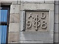
Date on building, Low Waters Road
1898 above a hairdressers.
Image: © Richard Webb
Taken: 20 Jun 2011
0.25 miles