IMAGES TAKEN NEAR TO
Portland Place, HAMILTON, ML3 7JU
Introduction
This page details the photographs taken nearby to Portland Place, ML3 7JU by members of the Geograph project.
The Geograph project started in 2005 with the aim of publishing, organising and preserving representative images for every square kilometre of Great Britain, Ireland and the Isle of Man.

There are currently over 7.5m images from over14,400 individuals and you can help contribute to the project by visiting https://www.geograph.org.uk
Image Map
Images are licensed for reuse under creativecommons.org/licenses/by-sa/2.0
Notes
- Clicking on the map will re-center to the selected point.
- The higher the marker number, the further away the image location is from the centre of the postcode.
Image Listing (36 Images Found)
Images are licensed for reuse under creativecommons.org/licenses/by-sa/2.0
Image
Details
Distance
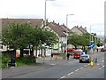
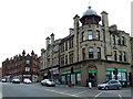
1
Junction of Portland Place and Johnstone Road, Hamilton
Image: © Nigel Thompson
Taken: 12 Feb 2019
0.04 miles
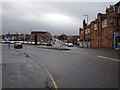
2
Low Waters Road, Hamilton (A723)
Looking down the main road into Hamilton from Strathaven.
Image: © G Laird
Taken: 7 Mar 2010
0.06 miles
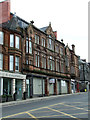
4
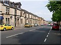
Looking down Low Waters Road in Hamilton
These buildings were erected in the late 19th century and there is a carved panel at the first floor level at the top of the row - see Image
Image: © Elliott Simpson
Taken: 22 May 2008
0.12 miles
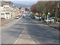
5
Low Waters Road
A long slow climbing road southwards out of Hamilton. Taken just before my chain snapped.
Image: © Richard Webb
Taken: 20 Jun 2011
0.14 miles
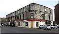
6
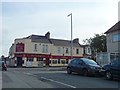
The Barleycorn
Pub on Low Waters Road, Hamilton.
Image: © Stephen Sweeney
Taken: 8 Oct 2014
0.16 miles
7
Polish Deli
On Quarry Street at Gateside Street.
Image: © Thomas Nugent
Taken: 9 Apr 2013
0.19 miles
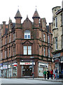
9
Red sandstone building on Quarry Street
Recently renovated on the upper floors, some work still to do at ground level.
Image: © Thomas Nugent
Taken: 9 Apr 2013
0.21 miles
10
Quarry Street
Kemp Street is on the right. Quarry Street goes to the right of the red sandstone building, Gateside Street to the left.
Image: © Thomas Nugent
Taken: 9 Apr 2013
0.21 miles