IMAGES TAKEN NEAR TO
Ambleside Rise, HAMILTON, ML3 7HJ
Introduction
This page details the photographs taken nearby to Ambleside Rise, ML3 7HJ by members of the Geograph project.
The Geograph project started in 2005 with the aim of publishing, organising and preserving representative images for every square kilometre of Great Britain, Ireland and the Isle of Man.

There are currently over 7.5m images from over14,400 individuals and you can help contribute to the project by visiting https://www.geograph.org.uk
Image Map
Images are licensed for reuse under creativecommons.org/licenses/by-sa/2.0
Notes
- Clicking on the map will re-center to the selected point.
- The higher the marker number, the further away the image location is from the centre of the postcode.
Image Listing (7 Images Found)
Images are licensed for reuse under creativecommons.org/licenses/by-sa/2.0
Image
Details
Distance
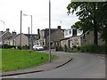
1
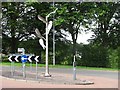
Sculpture on Strathaven Road
At the junction with Ambleside Rise which is a new residential street.
Image: © Richard Webb
Taken: 20 Jun 2011
0.10 miles
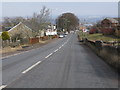
2
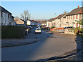
Strathaven Road
These older houses are now on the edge of Hamilton.
Image: © Richard Webb
Taken: 20 Jun 2011
0.11 miles
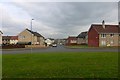
3
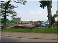
Entering Hamilton from the South
There has been a lot of house building in recent years in this vicinity. In the past, the only houses here were the few older houses on the left hand side of the road.
Image: © G Laird
Taken: 7 Mar 2010
0.13 miles
4
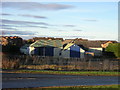
Eddlewood, Hamilton Place
Typical 1960s Lanarkshire council housing.
Image: © Robert Murray
Taken: 17 Oct 2015
0.15 miles