IMAGES TAKEN NEAR TO
Fergus Gardens, HAMILTON, ML3 7DF
Introduction
This page details the photographs taken nearby to Fergus Gardens, ML3 7DF by members of the Geograph project.
The Geograph project started in 2005 with the aim of publishing, organising and preserving representative images for every square kilometre of Great Britain, Ireland and the Isle of Man.

There are currently over 7.5m images from over14,400 individuals and you can help contribute to the project by visiting https://www.geograph.org.uk
Image Map
Images are licensed for reuse under creativecommons.org/licenses/by-sa/2.0
Notes
- Clicking on the map will re-center to the selected point.
- The higher the marker number, the further away the image location is from the centre of the postcode.
Image Listing (13 Images Found)
Images are licensed for reuse under creativecommons.org/licenses/by-sa/2.0
Image
Details
Distance
3
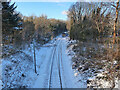
Railway line near Hamilton Station
The train is passing the site of two old collieries, Silverton Colliery was on the left of the railway and the line to Barncluith Colliery branched off to the right towards the camera.
The train is the 14.17 from Cumbernauld to Dalmuir but because of the adverse weather the train started at Motherwell.
Image: © wrobison
Taken: 10 Feb 2021
0.10 miles
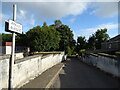
5
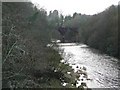
Looking upstream from Barncluith Bridge
The Avon flows down to its meeting with the Clyde; railway bridge and weir in the distance.
Image: © Gordon Brown
Taken: 21 Dec 2008
0.23 miles
6

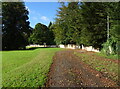
Pond: South Haugh
One of two large ponds in this area
Image: © Jim Smillie
Taken: 15 Oct 2021
0.23 miles
7
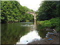
Bridge over the Avon Water
Looking downstream to the bridge carrying the railway from Larkhall to Hamilton and beyond - the Argyle Line to Glasgow Central, which was reopened in 2005.
Image: © M J Richardson
Taken: 15 Jul 2012
0.23 miles
8
Chatelherault Country Park
The old weir was associated with a large mill (demolished in the late 1990s) further down stream
Image: © Elliott Simpson
Taken: 1 Mar 2008
0.23 miles
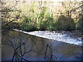
9

Weir on the Avon Water
Looking upstream from Old Avon Bridge to the weir and the crossing of the Argyle Line railway, reopened in 2005 and going from Larkhall to Glasgow Central.
Image: © M J Richardson
Taken: 15 Jul 2012
0.24 miles
10
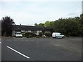
Smithycroft road junction
Both sections are called Smithycroft, as the road is a quadrant that intersects with itself. (If that makes sense.)
Image: © Stephen Sweeney
Taken: 8 Oct 2014
0.24 miles