IMAGES TAKEN NEAR TO
Glebe Street, HAMILTON, ML3 6UD
Introduction
This page details the photographs taken nearby to Glebe Street, ML3 6UD by members of the Geograph project.
The Geograph project started in 2005 with the aim of publishing, organising and preserving representative images for every square kilometre of Great Britain, Ireland and the Isle of Man.

There are currently over 7.5m images from over14,400 individuals and you can help contribute to the project by visiting https://www.geograph.org.uk
Image Map (Loading...)


Getting Data...Please wait
Leaflet Map data © OpenStreetMap
Images are licensed for reuse under creativecommons.org/licenses/by-sa/2.0
Notes
- Clicking on the map will re-center to the selected point.
- The higher the marker number, the further away the image location is from the centre of the postcode.
Image Listing (6 Images Found)
Images are licensed for reuse under creativecommons.org/licenses/by-sa/2.0
Image
Details
Distance
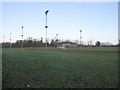
1
Old railway track at Bridge Street, Hamilton
The alignment of the old railway remains but the bridge that carried it over Bridge Street has gone.
Image: © wrobison
Taken: 25 Jan 2021
0.07 miles
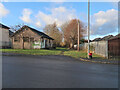
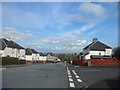
3
Roundabout on the B755 in Hamilton
The junction of Chantinghall Road (straight ahead), Bent Road (right), and Mill Road (from the camera position). Until the 1970s there was no roundabout here. Instead there was a large triangular traffic island.
Image: © G Laird
Taken: 14 Mar 2010
0.19 miles
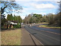
4
Bent Road
The road heading towards the B755.
Image: © Ross Watson
Taken: 13 Aug 2012
0.19 miles
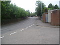
6
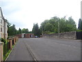
Bent Cemetery
Bent Cemetery on Bent Road.
Image: © Ross Watson
Taken: 13 Aug 2012
0.21 miles