IMAGES TAKEN NEAR TO
Whistleberry Drive, HAMILTON, ML3 0PZ
Introduction
This page details the photographs taken nearby to Whistleberry Drive, ML3 0PZ by members of the Geograph project.
The Geograph project started in 2005 with the aim of publishing, organising and preserving representative images for every square kilometre of Great Britain, Ireland and the Isle of Man.

There are currently over 7.5m images from over14,400 individuals and you can help contribute to the project by visiting https://www.geograph.org.uk
Image Map
Images are licensed for reuse under creativecommons.org/licenses/by-sa/2.0
Notes
- Clicking on the map will re-center to the selected point.
- The higher the marker number, the further away the image location is from the centre of the postcode.
Image Listing (7 Images Found)
Images are licensed for reuse under creativecommons.org/licenses/by-sa/2.0
Image
Details
Distance
1
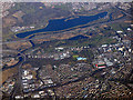
Burnbank and Strathclyde Loch from the air
Burnbank is on the left, Hamilton on the right, Bothwell Bridge is on the extreme left, crossing the Clyde.
Image: © Thomas Nugent
Taken: 19 Mar 2018
0.11 miles
2
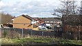
Whistleberry Wynd
New residential street seen from the turning circle at the end of the Whistleberry Industrial Estate.
Image: © Richard Webb
Taken: 4 Mar 2012
0.13 miles
3
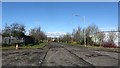
Whistleberry Industrial Estate
View north from the road end and turning circle.
Image: © Richard Webb
Taken: 4 Mar 2012
0.15 miles
4
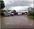
Lorry park, Whistleberry Park, Hamilton
Image: © Alex McGregor
Taken: 8 Jun 2011
0.16 miles
5

Turning circle in Whistleberry Industrial Estate
With the new housing estate visible in the background.
Image: © Stephen Sweeney
Taken: 17 Apr 2012
0.17 miles

7

Industrial premises in Whistleberry Industrial Estate
Image: © Stephen Sweeney
Taken: 17 Apr 2012
0.25 miles