IMAGES TAKEN NEAR TO
Morningside Road, WISHAW, ML2 9QS
Introduction
This page details the photographs taken nearby to Morningside Road, ML2 9QS by members of the Geograph project.
The Geograph project started in 2005 with the aim of publishing, organising and preserving representative images for every square kilometre of Great Britain, Ireland and the Isle of Man.

There are currently over 7.5m images from over14,400 individuals and you can help contribute to the project by visiting https://www.geograph.org.uk
Image Map (Loading...)


Getting Data...Please wait
Leaflet Map data © OpenStreetMap
Images are licensed for reuse under creativecommons.org/licenses/by-sa/2.0
Notes
- Clicking on the map will re-center to the selected point.
- The higher the marker number, the further away the image location is from the centre of the postcode.
Image Listing (8 Images Found)
Images are licensed for reuse under creativecommons.org/licenses/by-sa/2.0
Image
Details
Distance
1
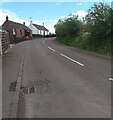
Cottages on corner: Chapel
Shown on 1912 map but not on older editions
Image: © Jim Smillie
Taken: 18 May 2021
0.01 miles
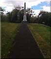
3
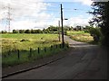
Morningside Road
Southwards from near the War Memorial.
Image: © Richard Webb
Taken: 16 Sep 2010
0.11 miles
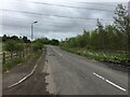
4
Young woodland, Chapel
Newly planted trees on what appears to be old mining land.
Image: © Richard Webb
Taken: 16 Sep 2010
0.11 miles
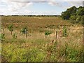
5
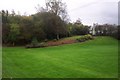
Morningside War Memorial
Pleasant grassy area at the southern edge of the North Lanarkshire village of Morningside, whose focus is the war memorial on the hillock.
Surrounding area has been desolate for several years due to opencast mining but is now being landscaped.
Image: © Stuart Brooks
Taken: 21 Oct 2006
0.12 miles
6
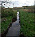
Auchter Water
About to pass under Morningside Road
Image: © Jim Smillie
Taken: 18 May 2021
0.18 miles
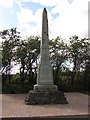
8
War Memorial off Morningside Road
Commemorating the fallen of Morningside and Chapel area
Image: © Jim Smillie
Taken: 18 May 2021
0.18 miles