IMAGES TAKEN NEAR TO
Crindledyke Crescent, WISHAW, ML2 9NQ
Introduction
This page details the photographs taken nearby to Crindledyke Crescent, ML2 9NQ by members of the Geograph project.
The Geograph project started in 2005 with the aim of publishing, organising and preserving representative images for every square kilometre of Great Britain, Ireland and the Isle of Man.

There are currently over 7.5m images from over14,400 individuals and you can help contribute to the project by visiting https://www.geograph.org.uk
Image Map (Loading...)


Getting Data...Please wait
Leaflet Map data © OpenStreetMap
Images are licensed for reuse under creativecommons.org/licenses/by-sa/2.0
Notes
- Clicking on the map will re-center to the selected point.
- The higher the marker number, the further away the image location is from the centre of the postcode.
Image Listing (14 Images Found)
Images are licensed for reuse under creativecommons.org/licenses/by-sa/2.0
Image
Details
Distance
1

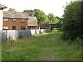
Houses backing onto the disused rail track at Newmains
Image: © Elliott Simpson
Taken: 1 Oct 2012
0.04 miles
2
Wishaw and Coltness Railway
Trackbed of a railway running to Morningside and then on through the coalfields to Bathgate. New houses have been built to the east, while elsewhere bings have been landscaped into an informal park.
Image: © Richard Webb
Taken: 16 Sep 2010
0.12 miles
3
Landscaped bing near Newmains
Restored mine waste, now an informal park.
Image: © Richard Webb
Taken: 16 Sep 2010
0.12 miles
4

Newmains Community Advice Centre
Former shops.
Image: © Richard Webb
Taken: 16 Sep 2010
0.13 miles
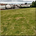
5

Summit of former spoil heap
This was grey slag waste from the steel works
Image: © Jim Smillie
Taken: 25 Jun 2021
0.14 miles
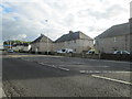
6
Looking to Eastwood Drive
Probably built as the property programmes describe as non-standard construction in the 1950's
Image: © Jim Smillie
Taken: 25 Jun 2021
0.15 miles
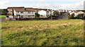
7
Housing at Newmains in North Lanarkshire
At the side of the A73.
Image: © James Denham
Taken: 14 Sep 2013
0.16 miles
8
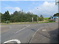
Newton Drive in Newmains joining Westwood Road (A73) in Newmains
Looking north-eastward.
Image: © Peter Wood
Taken: 15 Sep 2016
0.18 miles
9
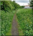
Path on old railway
Behind the houses on Kilmichael Avenue
Image: © Jim Smillie
Taken: 25 Jun 2021
0.20 miles
10
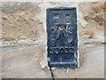
Ordnance Survey Flush Bracket S3032
This can be found on the wall of St Brigid's Church Centre in Newmains.
For more detail see : http://www.bench-marks.org.uk/bm10325
Image: © Peter Wood
Taken: 15 Sep 2016
0.22 miles