IMAGES TAKEN NEAR TO
McMahon Drive, WISHAW, ML2 9BS
Introduction
This page details the photographs taken nearby to McMahon Drive, ML2 9BS by members of the Geograph project.
The Geograph project started in 2005 with the aim of publishing, organising and preserving representative images for every square kilometre of Great Britain, Ireland and the Isle of Man.

There are currently over 7.5m images from over14,400 individuals and you can help contribute to the project by visiting https://www.geograph.org.uk
Image Map
Images are licensed for reuse under creativecommons.org/licenses/by-sa/2.0
Notes
- Clicking on the map will re-center to the selected point.
- The higher the marker number, the further away the image location is from the centre of the postcode.
Image Listing (12 Images Found)
Images are licensed for reuse under creativecommons.org/licenses/by-sa/2.0
Image
Details
Distance
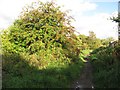
1
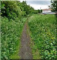
Path on old railway
Behind the houses on Kilmichael Avenue
Image: © Jim Smillie
Taken: 25 Jun 2021
0.13 miles
2
Christmas day 2007 Kilmichael avenue Newmains
Kilmichael avenue Newmains looking toward Calder avenue .
Taken Christmas day 2007 sun is out but it's still cold.
Image: © dan m
Taken: 25 Dec 2007
0.15 miles
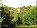
3
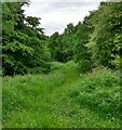
Path through South Plantation
Heading down to South Calder Water
Image: © Jim Smillie
Taken: 25 Jun 2021
0.17 miles
4
Path behind Murray Crescent
On the line of an old mineral railway
Image: © Jim Smillie
Taken: 25 Jun 2021
0.19 miles
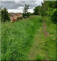
5
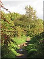
Wishaw and Coltness Railway
The trackbed of this closed, mostly coal hauling railway is now a tatty path, enlivened by rubbish dumped from local houses. View towards Newmains and Morningside.
On the left, steep wooded slopes fall to the South Calder Water.
Image: © Richard Webb
Taken: 16 Sep 2010
0.19 miles
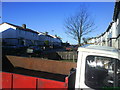
6
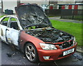
Burnt out car
Remains of a Lexus car burnt out by vandals on Guy Fawkes night.
Image: © dan m
Taken: 6 Nov 2009
0.20 miles
7
Wishaw and Coltness Railway
The trackbed of this closed, mostly coal hauling railway is now a tatty path, enlivened by rubbish dumped from local houses.
Image: © Richard Webb
Taken: 16 Sep 2010
0.21 miles
8

Newmains Community Advice Centre
Former shops.
Image: © Richard Webb
Taken: 16 Sep 2010
0.21 miles
10
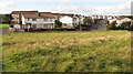
Landscaped bing near Newmains
Restored mine waste, now an informal park.
Image: © Richard Webb
Taken: 16 Sep 2010
0.24 miles