IMAGES TAKEN NEAR TO
Lockhart Place, WISHAW, ML2 8PP
Introduction
This page details the photographs taken nearby to Lockhart Place, ML2 8PP by members of the Geograph project.
The Geograph project started in 2005 with the aim of publishing, organising and preserving representative images for every square kilometre of Great Britain, Ireland and the Isle of Man.

There are currently over 7.5m images from over14,400 individuals and you can help contribute to the project by visiting https://www.geograph.org.uk
Image Map (Loading...)


Getting Data...Please wait
Leaflet Map data © OpenStreetMap
Images are licensed for reuse under creativecommons.org/licenses/by-sa/2.0
Notes
- Clicking on the map will re-center to the selected point.
- The higher the marker number, the further away the image location is from the centre of the postcode.
Image Listing (5 Images Found)
Images are licensed for reuse under creativecommons.org/licenses/by-sa/2.0
Image
Details
Distance
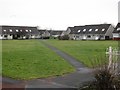
2
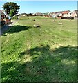
Site of Craig Place
A 1940's map shows this was a housing area with about 24 individual homes.
Possibly prefabs removed in later years
Image: © Jim Smillie
Taken: 15 Jul 2021
0.06 miles
3
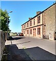
Tenement off Cambusnethan Street
Old maps show this was 10 houses, 247-255 with back entrances upstairs and 257-265 Cambusnethan Street at the front
Image: © Jim Smillie
Taken: 15 Jul 2021
0.06 miles
5
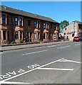
Red sandstone terrace
On Cambusnethan Street but panel in centre identifies it as Buccleuch Terrace
Image: © Jim Smillie
Taken: 15 Jul 2021
0.20 miles