IMAGES TAKEN NEAR TO
Greenfield Street, WISHAW, ML2 8NY
Introduction
This page details the photographs taken nearby to Greenfield Street, ML2 8NY by members of the Geograph project.
The Geograph project started in 2005 with the aim of publishing, organising and preserving representative images for every square kilometre of Great Britain, Ireland and the Isle of Man.

There are currently over 7.5m images from over14,400 individuals and you can help contribute to the project by visiting https://www.geograph.org.uk
Image Map
Images are licensed for reuse under creativecommons.org/licenses/by-sa/2.0
Notes
- Clicking on the map will re-center to the selected point.
- The higher the marker number, the further away the image location is from the centre of the postcode.
Image Listing (6 Images Found)
Images are licensed for reuse under creativecommons.org/licenses/by-sa/2.0
Image
Details
Distance
1
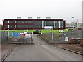
Coltness High School
New building nearing completion.
Image: © Richard Webb
Taken: 11 Feb 2011
0.20 miles
3
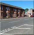
Red sandstone terrace
On Cambusnethan Street but panel in centre identifies it as Buccleuch Terrace
Image: © Jim Smillie
Taken: 15 Jul 2021
0.21 miles
4
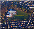
Coltness High School from the air
Several games of football are in progress at the school, which is in a suburb of Wishaw.
Image: © Thomas Nugent
Taken: 8 Dec 2017
0.24 miles
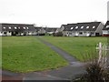
5
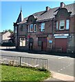
The Auld Hoose
Pub on the corner of Cambusnethan Street and West gate
Image: © Jim Smillie
Taken: 15 Jul 2021
0.24 miles
6
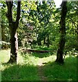
Fallen tree
On the path in a small wooded area beside Branchal Road
Image: © Jim Smillie
Taken: 15 Jul 2021
0.24 miles