IMAGES TAKEN NEAR TO
Tinto Crescent, WISHAW, ML2 8JB
Introduction
This page details the photographs taken nearby to Tinto Crescent, ML2 8JB by members of the Geograph project.
The Geograph project started in 2005 with the aim of publishing, organising and preserving representative images for every square kilometre of Great Britain, Ireland and the Isle of Man.

There are currently over 7.5m images from over14,400 individuals and you can help contribute to the project by visiting https://www.geograph.org.uk
Image Map
Images are licensed for reuse under creativecommons.org/licenses/by-sa/2.0
Notes
- Clicking on the map will re-center to the selected point.
- The higher the marker number, the further away the image location is from the centre of the postcode.
Image Listing (7 Images Found)
Images are licensed for reuse under creativecommons.org/licenses/by-sa/2.0
Image
Details
Distance
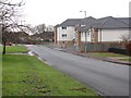
1
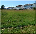
Houses on Tinto crescent
On the edge of the Greenhead Nature Reserve
Image: © Jim Smillie
Taken: 15 Jul 2021
0.06 miles
2
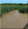
Ducks: Perchy Pond
On an inlet beside a viewing platform
Image: © Jim Smillie
Taken: 15 Jul 2021
0.09 miles
3
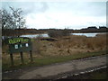
Perchy Pond Nature Reserve
Part of the Greenhead Moss Community Nature Park near Wishaw
Image: © Chris Wimbush
Taken: 20 Mar 2006
0.10 miles
4
Perchy Pond
A pond next to the Greenhead Moss Community Nature Park on the edge of Wishaw.
Image: © Alan O'Dowd
Taken: 5 Jun 2020
0.11 miles
5
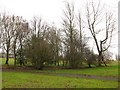
Park, Greenhead Road
Area of open ground with scattered trees, off Greenhead Road, Wishaw.
Image: © Richard Webb
Taken: 11 Feb 2011
0.18 miles
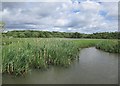
7
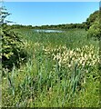
Marshy corner
The open water of Perchy Pond is some distance over the rushes and other marsh plants
Image: © Jim Smillie
Taken: 15 Jul 2021
0.21 miles