IMAGES TAKEN NEAR TO
Harestone Road, WISHAW, ML2 8DE
Introduction
This page details the photographs taken nearby to Harestone Road, ML2 8DE by members of the Geograph project.
The Geograph project started in 2005 with the aim of publishing, organising and preserving representative images for every square kilometre of Great Britain, Ireland and the Isle of Man.

There are currently over 7.5m images from over14,400 individuals and you can help contribute to the project by visiting https://www.geograph.org.uk
Image Map (Loading...)


Getting Data...Please wait
Leaflet Map data © OpenStreetMap
Images are licensed for reuse under creativecommons.org/licenses/by-sa/2.0
Notes
- Clicking on the map will re-center to the selected point.
- The higher the marker number, the further away the image location is from the centre of the postcode.
Image Listing (7 Images Found)
Images are licensed for reuse under creativecommons.org/licenses/by-sa/2.0
Image
Details
Distance
2
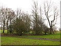
Park, Greenhead Road
Area of open ground with scattered trees, off Greenhead Road, Wishaw.
Image: © Richard Webb
Taken: 11 Feb 2011
0.19 miles
5
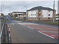
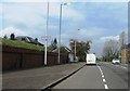
Mini-Roundabout on the A721 on the outskirts of Wishaw
Looking along the A721 towards Wishaw.
Where apartments are being built on the far side of the mini-roundabout used to be one of Barrs' factories.
Image: © G Laird
Taken: 16 Feb 2010
0.24 miles
6

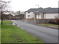
Stewarton Street, Wishaw
Stewarton Street, looking towards Magnum Sound and Mario's chipshop.
Image: © Ross Watson
Taken: 23 Jun 2012
0.25 miles