IMAGES TAKEN NEAR TO
East Thornlie Street, WISHAW, ML2 8BA
Introduction
This page details the photographs taken nearby to East Thornlie Street, ML2 8BA by members of the Geograph project.
The Geograph project started in 2005 with the aim of publishing, organising and preserving representative images for every square kilometre of Great Britain, Ireland and the Isle of Man.

There are currently over 7.5m images from over14,400 individuals and you can help contribute to the project by visiting https://www.geograph.org.uk
Image Map
Images are licensed for reuse under creativecommons.org/licenses/by-sa/2.0
Notes
- Clicking on the map will re-center to the selected point.
- The higher the marker number, the further away the image location is from the centre of the postcode.
Image Listing (17 Images Found)
Images are licensed for reuse under creativecommons.org/licenses/by-sa/2.0
Image
Details
Distance
1
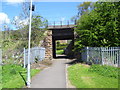
Wishaw Underpass
An underpass, at the Argyle Line.
Image: © Ross Watson
Taken: 22 May 2013
0.09 miles
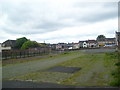
2
Derelict Land
The site of the former Wishaw Academy Primary School, now demolished.
Image: © Ross Watson
Taken: 22 May 2013
0.10 miles
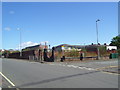
3
Open Area in Wishaw
The site of the former Wishaw Market, now mainly a car park.
Image: © Ross Watson
Taken: 23 Jun 2012
0.12 miles
4
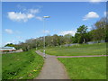
Wishaw Pathway
Pathway towards Argyle Line railway bridge, past Wishaw Abattoir.
Image: © Ross Watson
Taken: 22 May 2013
0.12 miles
5
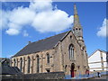
South Wishaw Parish Church
Formerly Chalmers Church, on East Academy Street.
Image: © Ross Watson
Taken: 22 May 2013
0.13 miles
6

Church in Wishaw
Former Thornlie Church, now amalgamated with Chalmers Church nearby, jointly known as South Wishaw Parish Church. This building is not now used for worship, but is still in use by the joint congregation for various functions.
Image: © Iain Thompson
Taken: 26 Dec 2005
0.14 miles
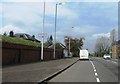
7

Stewarton Street, Wishaw
Stewarton Street, looking towards Magnum Sound and Mario's chipshop.
Image: © Ross Watson
Taken: 23 Jun 2012
0.15 miles
9
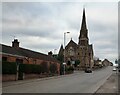
Former Church: Wishaw
Originally Thornlie Church then South Wishaw; now a Funeral Home
Image: © Jim Smillie
Taken: 27 Feb 2023
0.16 miles
