IMAGES TAKEN NEAR TO
Glencleland Road, WISHAW, ML2 7TU
Introduction
This page details the photographs taken nearby to Glencleland Road, ML2 7TU by members of the Geograph project.
The Geograph project started in 2005 with the aim of publishing, organising and preserving representative images for every square kilometre of Great Britain, Ireland and the Isle of Man.

There are currently over 7.5m images from over14,400 individuals and you can help contribute to the project by visiting https://www.geograph.org.uk
Image Map (Loading...)


Getting Data...Please wait
Leaflet Map data © OpenStreetMap
Images are licensed for reuse under creativecommons.org/licenses/by-sa/2.0
Notes
- Clicking on the map will re-center to the selected point.
- The higher the marker number, the further away the image location is from the centre of the postcode.
Image Listing (5 Images Found)
Images are licensed for reuse under creativecommons.org/licenses/by-sa/2.0
Image
Details
Distance
1
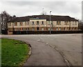
Building: Meadowhead Road
Identified as a 'Hostel' on 1940's map
Image: © Jim Smillie
Taken: 27 Feb 2023
0.17 miles
2
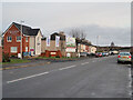
Meadowhead Road, Craigneuk, Wishaw
The Castings is a new housing development on part of the old Ravenscraig Steelworks site. The older houses are council houses built about the 1930s.
Image: © wrobison
Taken: 23 Dec 2020
0.19 miles
3
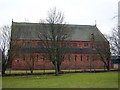
Large Church in Craigneuk
This church building had no signs indicating its name but I have been informed that it is St Patrick's RC church, opened in 1891.
Image: © Iain Thompson
Taken: 11 Mar 2006
0.20 miles
4
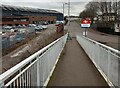
Looking down access ramp to John Street
Lanarkshire Welding works on left
Image: © Jim Smillie
Taken: 27 Feb 2023
0.21 miles
5
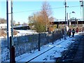
Shieldmuir Station
A lone passenger walks along the northern platform of the station having just got off a Glasgow Central to Lanark train.
Image: © Nigel Mykura
Taken: 27 Nov 2010
0.24 miles