IMAGES TAKEN NEAR TO
Ladysmith Street, WISHAW, ML2 7TE
Introduction
This page details the photographs taken nearby to Ladysmith Street, ML2 7TE by members of the Geograph project.
The Geograph project started in 2005 with the aim of publishing, organising and preserving representative images for every square kilometre of Great Britain, Ireland and the Isle of Man.

There are currently over 7.5m images from over14,400 individuals and you can help contribute to the project by visiting https://www.geograph.org.uk
Image Map
Images are licensed for reuse under creativecommons.org/licenses/by-sa/2.0
Notes
- Clicking on the map will re-center to the selected point.
- The higher the marker number, the further away the image location is from the centre of the postcode.
Image Listing (10 Images Found)
Images are licensed for reuse under creativecommons.org/licenses/by-sa/2.0
Image
Details
Distance
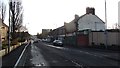
1
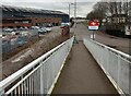
Looking down access ramp to John Street
Lanarkshire Welding works on left
Image: © Jim Smillie
Taken: 27 Feb 2023
0.05 miles
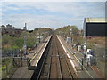
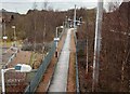
2
Shieldmuir Station
A lone passenger walks along the northern platform of the station having just got off a Glasgow Central to Lanark train.
Image: © Nigel Mykura
Taken: 27 Nov 2010
0.07 miles
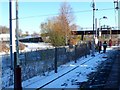
3
Shieldmuir railway station, Lanarkshire
Opened in 1990 by British Rail on the line from Motherwell to Carstairs.
View north west towards Motherwell and Glasgow.
Image: © Nigel Thompson
Taken: 15 Apr 2014
0.10 miles
4
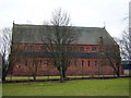
Large Church in Craigneuk
This church building had no signs indicating its name but I have been informed that it is St Patrick's RC church, opened in 1891.
Image: © Iain Thompson
Taken: 11 Mar 2006
0.10 miles
5
Path to Shieldmuir Station
Train about to leave, heading to Motherwell
Image: © Jim Smillie
Taken: 27 Feb 2023
0.11 miles
7
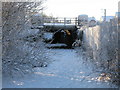
The Cuckoo Bridge (In Winter)
Compare this winter scene with my previous photograph Image where some background information is also available.
Image: © G Laird
Taken: 3 Jan 2010
0.21 miles
8
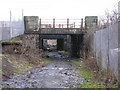
The Cuckoo Bridge
Despite appearances now to the contrary, until the mid 1960s it was possible to drive any car under this bridge along Excelsior Street which connected Shields Road and Craigneuk Street, the 2 main roads between Motherwell and Wishaw. Though just accessible by foot now from the north, it is now blocked from the south.
This bridge still carries the railway line at Shieldmuir junction where the Wishaw line branches off from the main south railway line.
Image: © G Laird
Taken: 18 Jan 2009
0.21 miles
9
Shieldmuir Street
The A721 Motherwell to Wishaw road.
Image: © Richard Webb
Taken: 9 Jan 2012
0.22 miles
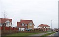
10
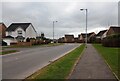
Modern Housing: Lochain Way
Lochnagar Road on left: Estate named as Colville Gardens on entrance wall
Image: © Jim Smillie
Taken: 27 Feb 2023
0.22 miles