IMAGES TAKEN NEAR TO
Glencairn Avenue, WISHAW, ML2 7RJ
Introduction
This page details the photographs taken nearby to Glencairn Avenue, ML2 7RJ by members of the Geograph project.
The Geograph project started in 2005 with the aim of publishing, organising and preserving representative images for every square kilometre of Great Britain, Ireland and the Isle of Man.

There are currently over 7.5m images from over14,400 individuals and you can help contribute to the project by visiting https://www.geograph.org.uk
Image Map
Images are licensed for reuse under creativecommons.org/licenses/by-sa/2.0
Notes
- Clicking on the map will re-center to the selected point.
- The higher the marker number, the further away the image location is from the centre of the postcode.
Image Listing (8 Images Found)
Images are licensed for reuse under creativecommons.org/licenses/by-sa/2.0
Image
Details
Distance
1
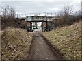
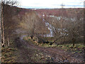
Bridge giving access to Glencairn Avenue
This side of bridge has tracks and footpaths for dog walkers etc
Image: © Jim Smillie
Taken: 27 Feb 2023
0.06 miles
2
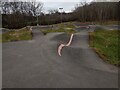
Wishawhill Wood Pump Track
Not quite as big as Image
Image: © Jim Smillie
Taken: 27 Feb 2023
0.09 miles
3

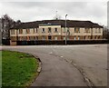
Former site of St Matthew's RC Primary School
Image: © Alex McGregor
Taken: 8 Jun 2011
0.16 miles
4

Site of former Ravenscraig Steelworks
The area to the east of the railway line.
Image: © Richard Sutcliffe
Taken: Unknown
0.17 miles
5
Building: Meadowhead Road
Identified as a 'Hostel' on 1940's map
Image: © Jim Smillie
Taken: 27 Feb 2023
0.19 miles
6
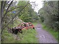
Vandalised car near Wishaw Golf Course
Probably once was a Peugeot 306
Image: © Chris Upson
Taken: 17 Sep 2006
0.19 miles
7
Part of the old Ravenscraig Steelworks site
The old iron ore stockyard and the only part of the site on the east side of the railway line and not included in the redevelopment plans. Now overgrown with birch trees, it is used as an unofficial adventure park.
Image: © wrobison
Taken: 23 Dec 2020
0.23 miles
8
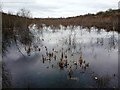
Flooded area in former industrial site
Ravenscraig Masterplan dated September 2018 does show development on this side of railway
Image: © Jim Smillie
Taken: 27 Feb 2023
0.24 miles