IMAGES TAKEN NEAR TO
St. Winifreds Way, WISHAW, ML2 7NW
Introduction
This page details the photographs taken nearby to St. Winifreds Way, ML2 7NW by members of the Geograph project.
The Geograph project started in 2005 with the aim of publishing, organising and preserving representative images for every square kilometre of Great Britain, Ireland and the Isle of Man.

There are currently over 7.5m images from over14,400 individuals and you can help contribute to the project by visiting https://www.geograph.org.uk
Image Map (Loading...)


Getting Data...Please wait
Leaflet Map data © OpenStreetMap
Images are licensed for reuse under creativecommons.org/licenses/by-sa/2.0
Notes
- Clicking on the map will re-center to the selected point.
- The higher the marker number, the further away the image location is from the centre of the postcode.
Image Listing (32 Images Found)
Images are licensed for reuse under creativecommons.org/licenses/by-sa/2.0
Image
Details
Distance
1
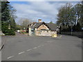
Glen Road, Wishaw
Glen Road, which continues to the right is the start of the old road to Cleland. This is near the end of that part of Glen Road which can be travelled by car. About 200 yards further on, it is only possible to proceed on foot along Glen Road (which later becomes Wishaw Low Road, again only possible on foot). St Winifreds Way, a small area of private housing, branches off to the left.
Image: © G Laird
Taken: 12 Apr 2009
0.04 miles
2
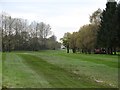
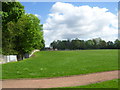
18th fairway, Wishaw Golf Club
The 404 yard par 18th seen from the road near the tee. The dogleg takes it into the neighbouring grid square.
Image: © Richard Webb
Taken: 24 Oct 2011
0.07 miles
3
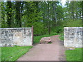
Templehall Plantation entrance
The entrance from Belhaven Park.
Image: © Ross Watson
Taken: 22 May 2013
0.09 miles
4
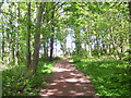
Templehall Plantation pathway
Pathway towards Carrick Crescent.
Image: © Ross Watson
Taken: 22 May 2013
0.11 miles
5
Sloped area
A gentle sloped area near Glen Road
Image: © Ross Watson
Taken: 22 May 2013
0.12 miles
6
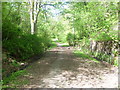
Glen Road pathway
Pathway near Wishaw golf course.
Image: © Ross Watson
Taken: 22 May 2013
0.13 miles
7
Red pathway
Formerly the site of a swing-park, now relocated.
Image: © Ross Watson
Taken: 22 May 2013
0.13 miles
8
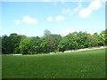
Park open area
Grassed area of Belhaven Park, with Templehall Plantation in the background.
Image: © Ross Watson
Taken: 22 May 2013
0.13 miles
9
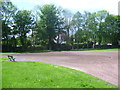
Play area
The main play area of Belhaven Park, taken from a distance.
Image: © Ross Watson
Taken: 22 May 2013
0.15 miles
10
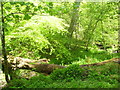
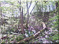
Temple Gill stream
A small stream near Glen Road, surrounded by plantations.
Image: © Ross Watson
Taken: 22 May 2013
0.16 miles