IMAGES TAKEN NEAR TO
Woodstock Drive, WISHAW, ML2 7DP

Introduction

This page details the photographs taken nearby to Woodstock Drive, ML2 7DP by members of the Geograph project.

The Geograph project started in 2005 with the aim of publishing, organising and preserving representative images for every square kilometre of Great Britain, Ireland and the Isle of Man.

There are currently over 7.5m images from over14,400 individuals and you can help contribute to the project by visiting https://www.geograph.org.uk

Image Map


Images are licensed for reuse under creativecommons.org/licenses/by-sa/2.0
Notes
  • Clicking on the map will re-center to the selected point.
  • The higher the marker number, the further away the image location is from the centre of the postcode.

Image Listing (15 Images Found)

Images are licensed for reuse under creativecommons.org/licenses/by-sa/2.0
Image
Details
Distance
1
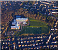
Coltness High School from the air
Several games of football are in progress at the school, which is in a suburb of Wishaw.
Image: © Thomas Nugent Taken: 8 Dec 2017
0.16 miles
2
Coltness from the air
Coltness High School is pominent. See also Image
Image: © Thomas Nugent Taken: 8 Dec 2017
0.17 miles
3
Cottages in Kirk Road
These cottages are just across the road from Cambusnethan Old Parish Kirk.
Image: © Anne Burgess Taken: 27 Oct 2018
0.19 miles
4
War Memorial Gateway
The arch was designed by Peter Macgregor Chalmers (1859-1922) and built in 1919-1920.
Image: © Anne Burgess Taken: 27 Oct 2018
0.19 miles
5
Mossland Drive
A residential street in Wishaw.
Image: © Richard Webb Taken: 11 Feb 2011
0.20 miles
6
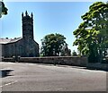
Greenhead Road at Kirk road
Cambusnethan Old Parish Church at the junction
Image: © Jim Smillie Taken: 15 Jul 2021
0.20 miles
7
Cambusnethan Old & Morningside Parish Church
On Kirk Road, Wishaw.
Image: © G Laird Taken: 5 Sep 2010
0.20 miles
8
Old Cambusnethan Kirk
Compare this with the Image
Image: © Anne Burgess Taken: 27 Oct 2018
0.23 miles
9
Old Parish Kirk
These are the ruins of the old parish kirk of Cambusnethan, which was built in the 1650s and abandoned in favour of a new kirk just to the west. Unusually for the 17th century, the builders' names are known: John Miller and Alexander King. The birdcage bellcote may have been added in about 1750.
Image: © Anne Burgess Taken: 27 Oct 2018
0.23 miles
10
Information Board
This information board stands just outside the ruins of the old parish kirk of Cambusnethan.
Image: © Anne Burgess Taken: 27 Oct 2018
0.23 miles