IMAGES TAKEN NEAR TO
Etive Crescent, WISHAW, ML2 0PJ
Introduction
This page details the photographs taken nearby to Etive Crescent, ML2 0PJ by members of the Geograph project.
The Geograph project started in 2005 with the aim of publishing, organising and preserving representative images for every square kilometre of Great Britain, Ireland and the Isle of Man.

There are currently over 7.5m images from over14,400 individuals and you can help contribute to the project by visiting https://www.geograph.org.uk
Image Map (Loading...)


Getting Data...Please wait
Leaflet Map data © OpenStreetMap
Images are licensed for reuse under creativecommons.org/licenses/by-sa/2.0
Notes
- Clicking on the map will re-center to the selected point.
- The higher the marker number, the further away the image location is from the centre of the postcode.
Image Listing (4 Images Found)
Images are licensed for reuse under creativecommons.org/licenses/by-sa/2.0
Image
Details
Distance
1
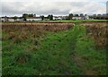
Looking over to Pather
A council estate of the south edge of Wishaw
Image: © Jim Smillie
Taken: 12 Oct 2023
0.10 miles
2
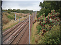
WCML between Overtown and Wishaw
This section of the WCML was built by the Wishaw and Coltness Railway in 1841 to serve the nearby Coltness Colliery. The line was extended to Chapel Colliery in 1842 and finally to Morningside in 1844, see https://en.wikipedia.org/wiki/Wishaw_and_Coltness_Railway . The Caledonian Railway from Carlisle joined the line at Garriongill Junction in 1848.
Looking NW towards the tower block near Motherwell station, 6km away.
Image: © wrobison
Taken: 11 Oct 2021
0.16 miles
3
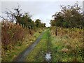
Iron gate posts beside track
1890's map shows Victoria Villa along here on right.
Image: © Jim Smillie
Taken: 12 Oct 2023
0.20 miles
4
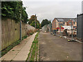
Hospital Road, Wishaw
Wishaw Hospital was on the left. Around 1875 there was a Smallpox Hospital on the site and this was replaced with a larger Fever Hospital in 1877. The hospital was closed in the late 1990s when the new Wishaw General Hospital was opened, see https://historic-hospitals.com/gazetteer/lanarkshire/
The building has since been demolished and replaced by houses and more houses are being built on the right.
Image: © wrobison
Taken: 11 Oct 2021
0.23 miles