IMAGES TAKEN NEAR TO
Tarbert Avenue, WISHAW, ML2 0JH
Introduction
This page details the photographs taken nearby to Tarbert Avenue, ML2 0JH by members of the Geograph project.
The Geograph project started in 2005 with the aim of publishing, organising and preserving representative images for every square kilometre of Great Britain, Ireland and the Isle of Man.

There are currently over 7.5m images from over14,400 individuals and you can help contribute to the project by visiting https://www.geograph.org.uk
Image Map
Images are licensed for reuse under creativecommons.org/licenses/by-sa/2.0
Notes
- Clicking on the map will re-center to the selected point.
- The higher the marker number, the further away the image location is from the centre of the postcode.
Image Listing (19 Images Found)
Images are licensed for reuse under creativecommons.org/licenses/by-sa/2.0
Image
Details
Distance
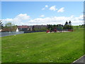
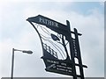
2
Pather
Pather homes and football parks.
Image: © Ross Watson
Taken: 22 May 2013
0.06 miles
3
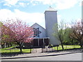
St. Thomas' Church
St. Thomas' Roman Catholic Church in Pather.
Image: © Ross Watson
Taken: 22 May 2013
0.06 miles
4
Pather Swingpark
A swing-park near Tarbert Avenue, Pather.
Image: © Ross Watson
Taken: 22 May 2013
0.07 miles
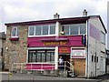
5

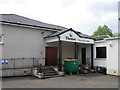
Abandoned Building
A dis-used building on Caledonian Road, Pather.
Image: © Ross Watson
Taken: 22 May 2013
0.07 miles
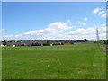
7
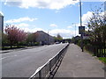
Caledonian Road
Caledonian Road in Pather, towards the West Coast Main Line railway bridge.
Image: © Ross Watson
Taken: 22 May 2013
0.08 miles
9
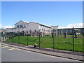
Thornlie Primary School
A primary School in Pather.
Image: © Ross Watson
Taken: 22 May 2013
0.12 miles
10
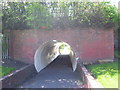
Pather tunnel
A tunnel under the West Coast Main Line railway bridge.
Image: © Ross Watson
Taken: 22 May 2013
0.14 miles