IMAGES TAKEN NEAR TO
Beltonfoot Way, WISHAW, ML2 0GA
Introduction
This page details the photographs taken nearby to Beltonfoot Way, ML2 0GA by members of the Geograph project.
The Geograph project started in 2005 with the aim of publishing, organising and preserving representative images for every square kilometre of Great Britain, Ireland and the Isle of Man.

There are currently over 7.5m images from over14,400 individuals and you can help contribute to the project by visiting https://www.geograph.org.uk
Image Map (Loading...)


Getting Data...Please wait
Leaflet Map data © OpenStreetMap
Images are licensed for reuse under creativecommons.org/licenses/by-sa/2.0
Notes
- Clicking on the map will re-center to the selected point.
- The higher the marker number, the further away the image location is from the centre of the postcode.
Image Listing (13 Images Found)
Images are licensed for reuse under creativecommons.org/licenses/by-sa/2.0
Image
Details
Distance
1
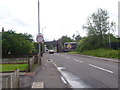
Road to Netherton
The road towards Netherton, with the West Coast Main Line going over it.
Image: © Ross Watson
Taken: 23 Jun 2012
0.12 miles
2
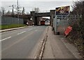
Railway Bridge: Netherton Street
There were temporary traffic lights just through the bridge
Image: © Jim Smillie
Taken: 27 Feb 2023
0.12 miles
3
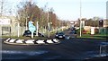
Netherton Street
The junction with Netherton Road in an industrial area, a train heads south over the bridge.
Image: © Richard Webb
Taken: 9 Jan 2012
0.14 miles
4
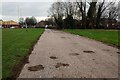
No through road
Identified as Marshall Street; only pedestrian access now at far end
Image: © Jim Smillie
Taken: 27 Feb 2023
0.15 miles
5
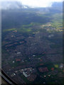
Wishaw from the air
Viewed from a Glasgow bound flight from Gatwick.
Image: © Thomas Nugent
Taken: 28 Jun 2011
0.16 miles
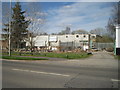
6
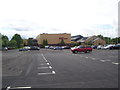
Wishaw Sports Centre
Sports Centre and car park.
Image: © Ross Watson
Taken: 23 Jun 2012
0.20 miles
7
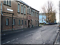
Pickering House, Netherton Road, Wishaw
Site of the former Railway Carriage, Wagon and Wheel Works of R.Y. Pickering and Co. For more information see https://archiveshub.jisc.ac.uk/search/archives/04a44676-781a-3a92-bb9a-de02819462c2 and https://www.gracesguide.co.uk/R._Y._Pickering_and_Co
Image: © wrobison
Taken: 12 Jan 2021
0.20 miles
8
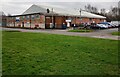
Lanarkshire Indoor Bowling Club
There is an outdoor green just beyond it in the neighbouring square
Image: © Jim Smillie
Taken: 27 Feb 2023
0.20 miles
9
Wishaw (South) railway station (site), Lanarkshire
Opened c.1844 as "Wishaw" by the Wishaw and Coltness Railway on the line from Motherwell to Carstairs, this station became Wishaw South in 1880. It closed to passengers in 1958.
View north east from Netherton Road. The building in the left foreground behind the conifer is on the site of the old goods shed. The station was up on the embankment behind, just visible to the right of this building group.
Image: © Nigel Thompson
Taken: 15 Apr 2014
0.22 miles
10
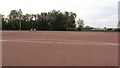
Blaes pitch, Wishaw
The blaes is not such a common sight now. This is a goalkeeper's view of a pitch at Wishaw Sports Centre. It is one of three floodlit blaes pitches.
Image: © Richard Webb
Taken: 24 Oct 2011
0.23 miles