IMAGES TAKEN NEAR TO
Carbarns West, WISHAW, ML2 0DE
Introduction
This page details the photographs taken nearby to Carbarns West, ML2 0DE by members of the Geograph project.
The Geograph project started in 2005 with the aim of publishing, organising and preserving representative images for every square kilometre of Great Britain, Ireland and the Isle of Man.

There are currently over 7.5m images from over14,400 individuals and you can help contribute to the project by visiting https://www.geograph.org.uk
Image Map (Loading...)


Getting Data...Please wait
Leaflet Map data © OpenStreetMap
Images are licensed for reuse under creativecommons.org/licenses/by-sa/2.0
Notes
- Clicking on the map will re-center to the selected point.
- The higher the marker number, the further away the image location is from the centre of the postcode.
Image Listing (4 Images Found)
Images are licensed for reuse under creativecommons.org/licenses/by-sa/2.0
Image
Details
Distance
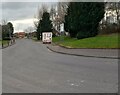
1

Roundabout and shops, Netherton Road, Wishaw
There used to be a railway crossing the road near here. Initially it was built to serve coal mines including the Clydesdale Coal Pit which was situated behind where the shops are now. By 1896 the site was used by the Clydesdale Wagon Works and in 1940 it was the Clydesdale Engineering Works. The final occupant was, I think, the scrapyard of T.W. Ward. The railway was removed about 1980 and there is now no trace of the industrial past.
Image: © wrobison
Taken: 12 Jan 2021
0.18 miles
2
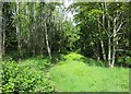
Woodland path near Carbarns Road
Young trees close to the urban fringe on the outskirts of Wishaw.
Image: © Alan O'Dowd
Taken: 7 Jun 2020
0.20 miles
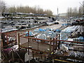
4
McMillan Road: Netherton Industrial Estate
With the obligatory 'snack van'
Image: © Jim Smillie
Taken: 27 Feb 2023
0.24 miles