IMAGES TAKEN NEAR TO
Rosehall Terrace, WISHAW, ML2 0AG
Introduction
This page details the photographs taken nearby to Rosehall Terrace, ML2 0AG by members of the Geograph project.
The Geograph project started in 2005 with the aim of publishing, organising and preserving representative images for every square kilometre of Great Britain, Ireland and the Isle of Man.

There are currently over 7.5m images from over14,400 individuals and you can help contribute to the project by visiting https://www.geograph.org.uk
Image Map (Loading...)


Getting Data...Please wait
Leaflet Map data © OpenStreetMap
Images are licensed for reuse under creativecommons.org/licenses/by-sa/2.0
Notes
- Clicking on the map will re-center to the selected point.
- The higher the marker number, the further away the image location is from the centre of the postcode.
Image Listing (8 Images Found)
Images are licensed for reuse under creativecommons.org/licenses/by-sa/2.0
Image
Details
Distance
2
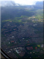
Wishaw from the air
Viewed from a Glasgow bound flight from Gatwick.
Image: © Thomas Nugent
Taken: 28 Jun 2011
0.15 miles
3

Rear of older brick built factory units
It turned out that none of these was operational
Image: © Jim Smillie
Taken: 27 Feb 2023
0.16 miles
4
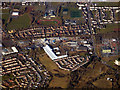
Wishaw from the air
The Netherton Road industrial area is in the foreground, Gowkthrapple substation is on the right.
Image: © Thomas Nugent
Taken: 19 Mar 2018
0.18 miles
5
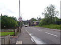
Netherton Street
The junction with Netherton Road in an industrial area, a train heads south over the bridge.
Image: © Richard Webb
Taken: 9 Jan 2012
0.19 miles
6
Netherton Industrial Estate Near Wishaw
Image: © Iain Thompson
Taken: 11 Mar 2006
0.20 miles
7
Road to Netherton
The road towards Netherton, with the West Coast Main Line going over it.
Image: © Ross Watson
Taken: 23 Jun 2012
0.21 miles
8
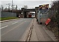
Railway Bridge: Netherton Street
There were temporary traffic lights just through the bridge
Image: © Jim Smillie
Taken: 27 Feb 2023
0.21 miles