IMAGES TAKEN NEAR TO
McNeil Drive, MOTHERWELL, ML1 4UR
Introduction
This page details the photographs taken nearby to McNeil Drive, ML1 4UR by members of the Geograph project.
The Geograph project started in 2005 with the aim of publishing, organising and preserving representative images for every square kilometre of Great Britain, Ireland and the Isle of Man.

There are currently over 7.5m images from over14,400 individuals and you can help contribute to the project by visiting https://www.geograph.org.uk
Image Map
Images are licensed for reuse under creativecommons.org/licenses/by-sa/2.0
Notes
- Clicking on the map will re-center to the selected point.
- The higher the marker number, the further away the image location is from the centre of the postcode.
Image Listing (4 Images Found)
Images are licensed for reuse under creativecommons.org/licenses/by-sa/2.0
Image
Details
Distance
1

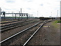
Eurocentral Rail Terminal
Looking towards this large facility at Eurocentral, viewed from the access road just outside the square.
Image: © Mary and Angus Hogg
Taken: 2 Aug 2013
0.02 miles
2
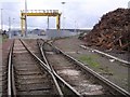
Motherwell to Coatbridge Railway Line
At the point where the line passes the Eurocentral Rail Terminal.
Image: © G Laird
Taken: 26 Jul 2011
0.10 miles
4
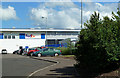
FedEx at Eurocentral
Viewed from McNeil Drive, one of many international carriers that are based at Eurocentral.
Image: © Mary and Angus Hogg
Taken: 2 Aug 2013
0.21 miles