IMAGES TAKEN NEAR TO
Crabb Quadrant, MOTHERWELL, ML1 3UR
Introduction
This page details the photographs taken nearby to Crabb Quadrant, ML1 3UR by members of the Geograph project.
The Geograph project started in 2005 with the aim of publishing, organising and preserving representative images for every square kilometre of Great Britain, Ireland and the Isle of Man.

There are currently over 7.5m images from over14,400 individuals and you can help contribute to the project by visiting https://www.geograph.org.uk
Image Map (Loading...)


Getting Data...Please wait
Leaflet Map data © OpenStreetMap
Images are licensed for reuse under creativecommons.org/licenses/by-sa/2.0
Notes
- Clicking on the map will re-center to the selected point.
- The higher the marker number, the further away the image location is from the centre of the postcode.
Image Listing (6 Images Found)
Images are licensed for reuse under creativecommons.org/licenses/by-sa/2.0
Image
Details
Distance
3
Entrance: South Calder Walkway
From corner of small carpark on Nethan Street
Image: © Jim Smillie
Taken: 28 Nov 2022
0.22 miles
4
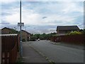
Bellshill Road
Bellshill Road (A721) going through Forgewood.
Image: © Ross Watson
Taken: 19 Jul 2012
0.22 miles
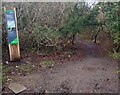
5
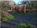
Insect Corner
Information on the left-hand post
Image: © Jim Smillie
Taken: 28 Nov 2022
0.22 miles
6
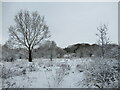
Snow near Forgewood
View from a path leading from the path to the Calder towards the Forgewood area of Motherwell, after an early-morning snowfall.
Image: © Alan O'Dowd
Taken: 24 Feb 2022
0.24 miles