IMAGES TAKEN NEAR TO
Valley View, MOTHERWELL, ML1 2DE
Introduction
This page details the photographs taken nearby to Valley View, ML1 2DE by members of the Geograph project.
The Geograph project started in 2005 with the aim of publishing, organising and preserving representative images for every square kilometre of Great Britain, Ireland and the Isle of Man.

There are currently over 7.5m images from over14,400 individuals and you can help contribute to the project by visiting https://www.geograph.org.uk
Image Map
Images are licensed for reuse under creativecommons.org/licenses/by-sa/2.0
Notes
- Clicking on the map will re-center to the selected point.
- The higher the marker number, the further away the image location is from the centre of the postcode.
Image Listing (29 Images Found)
Images are licensed for reuse under creativecommons.org/licenses/by-sa/2.0
Image
Details
Distance
1
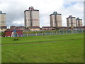
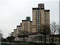
Sports Surface
Football and basketball park in front of Muirhouse Tower Blocks.
Image: © Ross Watson
Taken: 16 Aug 2012
0.05 miles
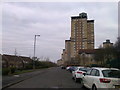
2
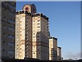
Tower blocks
Row of towers along Shields Drive, Muirhouse.
Image: © Richard Webb
Taken: 9 Jan 2012
0.07 miles
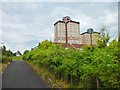
3
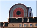
Detail, tower block
One of the Muirhouse towers. The "summit" detail appeared around 2000.
Image: © Richard Webb
Taken: 9 Jan 2012
0.07 miles
4
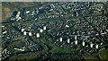
Muirhouse, Motherwell from the air
The thirteen Muirhouse towerblocks can be seen.
Image: © Thomas Nugent
Taken: 19 Dec 2024
0.08 miles
7
High flats in Muirhouse
Exiting Dalzell Park to the east. This area has several towerblocks in a condensed area.
Image: © Stephen Sweeney
Taken: 17 Jun 2013
0.09 miles
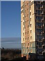
8
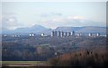
Muirhouse flats
Ben Lomond, Dumgoyne and Earl's Seat form a backdrop to the Motherwell landmark.
Image: © Richard Webb
Taken: 4 Mar 2012
0.10 miles
10
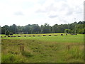
Outdoor grass football pitch
Floodlit grass park next to Dalzell Burn.
Image: © Ross Watson
Taken: 16 Aug 2012
0.12 miles