IMAGES TAKEN NEAR TO
Manse Road, BIGGAR, ML12 6SR
Introduction
This page details the photographs taken nearby to Manse Road, ML12 6SR by members of the Geograph project.
The Geograph project started in 2005 with the aim of publishing, organising and preserving representative images for every square kilometre of Great Britain, Ireland and the Isle of Man.

There are currently over 7.5m images from over14,400 individuals and you can help contribute to the project by visiting https://www.geograph.org.uk
Image Map
Images are licensed for reuse under creativecommons.org/licenses/by-sa/2.0
Notes
- Clicking on the map will re-center to the selected point.
- The higher the marker number, the further away the image location is from the centre of the postcode.
Image Listing (59 Images Found)
Images are licensed for reuse under creativecommons.org/licenses/by-sa/2.0
Image
Details
Distance
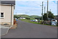
3
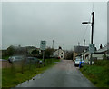
Crawfordjohn - Main Street becomes Manse Road
Looking north-eastward.
Image: © Peter Wood
Taken: 11 Sep 2017
0.03 miles
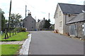
5
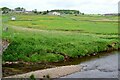
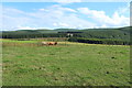
Crawfordjohn from the Duneaton Water
The village seen from the road bridge. The prominent building is the village hall.
Image: © Jim Barton
Taken: 15 Jun 2021
0.03 miles
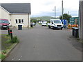
6
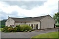
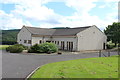
Crawfordjohn village hall
The hall has an adjacent car park on the east side of the village.
Image: © Jim Barton
Taken: 15 Jun 2021
0.03 miles
7
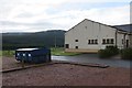
Crawfordjohn Community Hall
And recycling facility.
Image: © Richard Webb
Taken: 15 Aug 2014
0.03 miles