IMAGES TAKEN NEAR TO
Wood Crescent, MOTHERWELL, ML1 1HW
Introduction
This page details the photographs taken nearby to Wood Crescent, ML1 1HW by members of the Geograph project.
The Geograph project started in 2005 with the aim of publishing, organising and preserving representative images for every square kilometre of Great Britain, Ireland and the Isle of Man.

There are currently over 7.5m images from over14,400 individuals and you can help contribute to the project by visiting https://www.geograph.org.uk
Image Map
Images are licensed for reuse under creativecommons.org/licenses/by-sa/2.0
Notes
- Clicking on the map will re-center to the selected point.
- The higher the marker number, the further away the image location is from the centre of the postcode.
Image Listing (9 Images Found)
Images are licensed for reuse under creativecommons.org/licenses/by-sa/2.0
Image
Details
Distance
1

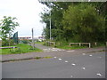
Cycle Path signage
The signage of the Greenlink Cycle Path, joining onto another path.
Image: © Ross Watson
Taken: 15 Aug 2012
0.10 miles
2
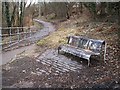
The Greenlink cycleway
An uninviting seat on the cycleway where it joins the road to the old Globe Cemetery
Image: © wrobison
Taken: 23 Mar 2010
0.15 miles
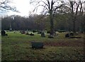
3

Burial Ground
The abandoned burial ground by the South Calder, Motherwell.
Image: © Paul Macrae
Taken: 16 Apr 2006
0.16 miles
4
Globe Burial Ground
The CWGC has 20 servicemen commemorated here
Image: © Jim Smillie
Taken: 28 Nov 2022
0.17 miles
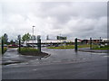
5

Cathedral Primary and Fir Park Nursery
The Greenlink Cycle Path by-passing the new joint-campus.
Image: © Ross Watson
Taken: 15 Aug 2012
0.18 miles
6
Cyclepath metal fencing
Fencing on the Cycle Path.
Image: © Ross Watson
Taken: 15 Aug 2012
0.19 miles
7
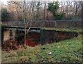
Footbridge over South Calder
Identified as Camp Bridge on 1859 map
Image: © Jim Smillie
Taken: 28 Nov 2022
0.24 miles
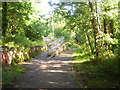
8
Cycle way past school
Greenlink Cycle Path going past Cathedral Primary School.
Image: © Ross Watson
Taken: 13 Aug 2012
0.24 miles
9
New school/nursery
The new Cathedral Primary School/Fir Park Nursery.
Image: © Ross Watson
Taken: 22 Jun 2012
0.25 miles