IMAGES TAKEN NEAR TO
Brocketsbrae Road, LANARK, ML11 9PT
Introduction
This page details the photographs taken nearby to Brocketsbrae Road, ML11 9PT by members of the Geograph project.
The Geograph project started in 2005 with the aim of publishing, organising and preserving representative images for every square kilometre of Great Britain, Ireland and the Isle of Man.

There are currently over 7.5m images from over14,400 individuals and you can help contribute to the project by visiting https://www.geograph.org.uk
Image Map
Images are licensed for reuse under creativecommons.org/licenses/by-sa/2.0
Notes
- Clicking on the map will re-center to the selected point.
- The higher the marker number, the further away the image location is from the centre of the postcode.
Image Listing (18 Images Found)
Images are licensed for reuse under creativecommons.org/licenses/by-sa/2.0
Image
Details
Distance
2
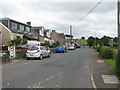
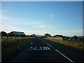
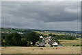
Brocketsbrae
Small village near Lesmahagow.
Image: © G Laird
Taken: 14 Aug 2013
0.06 miles
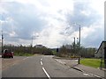
6
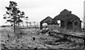
Brocketsbrae Station (remains)
View southward, towards Coalburn; ex-Caledonian Railway Glasgow - Hamilton - Coalburn line. Station closed to passengers 1/10/51, to goods 21/9/53, the line being closed 4/10/65. (A scene of desolation in 1970).
Image: © Ben Brooksbank
Taken: 15 Mar 1970
0.10 miles
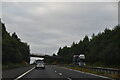
9
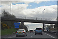
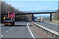
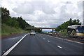
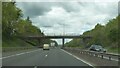
South Lanarkshire : The M74 Motorway
Heading along the M74 motorway.
Image: © Lewis Clarke
Taken: 25 Apr 2016
0.11 miles